

kidsbike: Holzmaden-Schafhof-Kreuzeiche
A cycling route starting in Holzmaden, Baden-Wurttemberg, Germany.
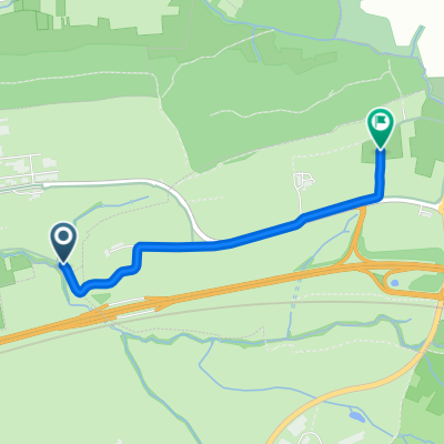
Overview
About this route
Cycling tour with kids
Starting point: Community hall Holzmaden
Resting options: Barbecue area at Kreuzeiche and at the community hall Holzmaden
- -:--
- Duration
- 13.3 km
- Distance
- 135 m
- Ascent
- 137 m
- Descent
- ---
- Avg. speed
- ---
- Max. altitude
Route quality
Waytypes & surfaces along the route
Waytypes
Track
7.7 km
(58 %)
Quiet road
2.7 km
(20 %)
Surfaces
Paved
6.8 km
(51 %)
Unpaved
3.7 km
(28 %)
Asphalt
5.2 km
(39 %)
Gravel
3.3 km
(25 %)
Route highlights
Points of interest along the route
Point of interest after 10.4 km
Grillplatz an der Kreuzeiche Spielgeräte großteils defekt
Point of interest after 13.1 km
Grillstelle hinter der Gemeindehalle mit schönem Spielplatz und Skateranlage. Pizzeria gegenüber des Sportgeländes
Continue with Bikemap
Use, edit, or download this cycling route
You would like to ride kidsbike: Holzmaden-Schafhof-Kreuzeiche or customize it for your own trip? Here is what you can do with this Bikemap route:
Free features
- Save this route as favorite or in collections
- Copy & plan your own version of this route
- Sync your route with Garmin or Wahoo
Premium features
Free trial for 3 days, or one-time payment. More about Bikemap Premium.
- Navigate this route on iOS & Android
- Export a GPX / KML file of this route
- Create your custom printout (try it for free)
- Download this route for offline navigation
Discover more Premium features.
Get Bikemap PremiumFrom our community
Other popular routes starting in Holzmaden
 Recovered Route
- Distance
- 13 km
- Ascent
- 111 m
- Descent
- 103 m
- Location
- Holzmaden, Baden-Wurttemberg, Germany
 kidsbike: Holzmaden-Schafhof-Kreuzeiche
- Distance
- 13.3 km
- Ascent
- 135 m
- Descent
- 137 m
- Location
- Holzmaden, Baden-Wurttemberg, Germany
 Steinwiesen nach Bunzenberg
- Distance
- 2.3 km
- Ascent
- 39 m
- Descent
- 57 m
- Location
- Holzmaden, Baden-Wurttemberg, Germany
 Kirchheimer Straße 4, Holzmaden nach Kornhausstraße 4, Schwäbisch Gmünd
- Distance
- 41 km
- Ascent
- 256 m
- Descent
- 286 m
- Location
- Holzmaden, Baden-Wurttemberg, Germany
 GraphHopper Track
- Distance
- 19.6 km
- Ascent
- 131 m
- Descent
- 131 m
- Location
- Holzmaden, Baden-Wurttemberg, Germany
 Ausfahrt durch Kirchheim unter Teck
- Distance
- 20.3 km
- Ascent
- 62 m
- Descent
- 60 m
- Location
- Holzmaden, Baden-Wurttemberg, Germany
 kidsbike: Holzmaden-Nabern-Weilheim
- Distance
- 13.1 km
- Ascent
- 162 m
- Descent
- 160 m
- Location
- Holzmaden, Baden-Wurttemberg, Germany
 Jesingen Westerheim über Hepsisau
- Distance
- 26.4 km
- Ascent
- 655 m
- Descent
- 170 m
- Location
- Holzmaden, Baden-Wurttemberg, Germany
Open it in the app