
fdfsf
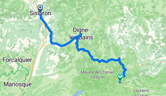
A cycling route starting in Sisteron, Provence-Alpes-Côte d'Azur Region, France.
Overview
About this route
fdsfdsfs
- -:--
- Duration
- 103.4 km
- Distance
- 1,232 m
- Ascent
- 870 m
- Descent
- ---
- Avg. speed
- 860 m
- Max. altitude
Route quality
Waytypes & surfaces along the route
Waytypes
Busy road
76.6 km
(74 %)
Quiet road
9.9 km
(10 %)
Surfaces
Paved
83.2 km
(80 %)
Unpaved
1.7 km
(2 %)
Asphalt
79.7 km
(77 %)
Paved (undefined)
3.5 km
(3 %)
Continue with Bikemap
Use, edit, or download this cycling route
You would like to ride fdfsf or customize it for your own trip? Here is what you can do with this Bikemap route:
Free features
- Save this route as favorite or in collections
- Copy & plan your own version of this route
- Split it into stages to create a multi-day tour
- Sync your route with Garmin or Wahoo
Premium features
Free trial for 3 days, or one-time payment. More about Bikemap Premium.
- Navigate this route on iOS & Android
- Export a GPX / KML file of this route
- Create your custom printout (try it for free)
- Download this route for offline navigation
Discover more Premium features.
Get Bikemap PremiumFrom our community
Other popular routes starting in Sisteron
 Sisteron - Bedoin - Mont Ventoux - Malaucene
- Distance
- 135.5 km
- Ascent
- 2,625 m
- Descent
- 2,776 m
- Location
- Sisteron, Provence-Alpes-Côte d'Azur Region, France
 4. Tag Sisteron - Moustiers
- Distance
- 88.8 km
- Ascent
- 722 m
- Descent
- 613 m
- Location
- Sisteron, Provence-Alpes-Côte d'Azur Region, France
 France Ultime : Avignon - Sisteron
- Distance
- 196.1 km
- Ascent
- 2,816 m
- Descent
- 3,223 m
- Location
- Sisteron, Provence-Alpes-Côte d'Azur Region, France
 Gap to Digne to Château-Arnoux-Saint-Auban
- Distance
- 73.1 km
- Ascent
- 344 m
- Descent
- 376 m
- Location
- Sisteron, Provence-Alpes-Côte d'Azur Region, France
 Route nach Nizza
- Distance
- 218.5 km
- Ascent
- 4,583 m
- Descent
- 5,061 m
- Location
- Sisteron, Provence-Alpes-Côte d'Azur Region, France
 10-M. Sisteron - Aix-En-Provence (144 Km)
- Distance
- 144 km
- Ascent
- 2,121 m
- Descent
- 2,394 m
- Location
- Sisteron, Provence-Alpes-Côte d'Azur Region, France
 Tour de France 2016 dzień 12
- Distance
- 104.6 km
- Ascent
- 295 m
- Descent
- 600 m
- Location
- Sisteron, Provence-Alpes-Côte d'Azur Region, France
 Alpentocht 2015 alternatief dag 4: Sisteron - Sault
- Distance
- 113 km
- Ascent
- 1,848 m
- Descent
- 1,589 m
- Location
- Sisteron, Provence-Alpes-Côte d'Azur Region, France
Open it in the app