Riedpfad 13, Edesheim nach Einlaubstraße 64, St. Martin
- 7.7 km
- 185 m
- 28 m
- Edesheim, Rhineland-Palatinate, Germany
A cycling route starting in Edesheim, Rhineland-Palatinate, Germany.
Overview
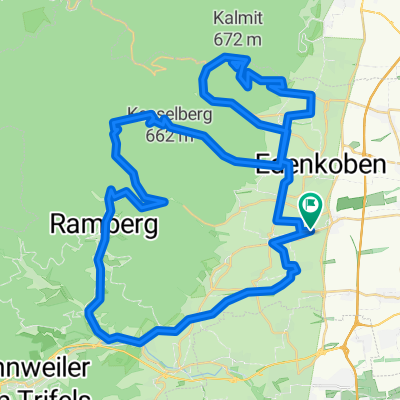
All climbs of Haardt combined in one tour. First, it's flat to slightly hilly along the Wine Route to NW-Hambach, where the first climb, the Hambach Castle, awaits. After a rapid descent through Hambach, the route leads back to Maikammer, where one turns right into the climb to Kalmit, whose peak is reached after 7.7 km and 500 m of elevation. After a possible quick refueling at the local tavern, one rides downhill to Edenkoben via St. Martin. There, one follows Klosterstraße towards the forest. Along Hilschweier, the road starts to rise moderately, becoming noticeably steeper from Hüttebrunnen towards Lollosruhe at 576 m above sea level. A beautiful and fast descent via Forsthaus Heldenstein/Schänzel takes one into the idyllic Modenbach Valley, which is quickly left behind, as the next mountain approaches: 1.8 km and 130 m of elevation have to be tackled on the way to the Three Beech Pass, beyond which an unpleasant descent due to poor asphalt follows down to Ramberg. Through Dernbach, one continues until reaching the junction onto the L505, which leads into and through the secluded Eußerthal up to Taubensuhl (534 m). Here one rides along an official 'country road', but in fact, it is an unpaved path (those with narrow tires unfortunately must push) down to the B48, which continues to Rinnthal and Annweiler. Once again, one must pedal a few more meters uphill, from Albersweiler to Frankweiler, from where one can roll back to Edesheim.
created this 16 years ago
Route quality
Quiet road
24.8 km
(24 %)
Road
18.6 km
(18 %)
Paved
82.7 km
(80 %)
Unpaved
15.5 km
(15 %)
Asphalt
80.7 km
(78 %)
Gravel
6.2 km
(6 %)
Route highlights
Hambacher Schloss, 375m
Kalmit, 673m
Lolosruhe, 574m
Drei Buchen, 403m
Forsthaus Taubensuhl, 510m
Continue with Bikemap
You would like to ride Haardt(e) Klettertour or customize it for your own trip? Here is what you can do with this Bikemap route:
Free trial for 3 days, or one-time payment. More about Bikemap Premium.
Discover more Premium features.
Get Bikemap PremiumFrom our community
Open it in the app