

Szelkó-tó kerékpártúra CLONED FROM ROUTE 2108575
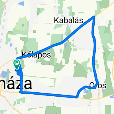
A cycling route starting in Nyíregyháza, Szabolcs-Szatmár-Bereg, Hungary.
Overview
About this route
Meeting: In front of the Arany J. Gymnasium swimming pool - we cross Tas Street in front of the school - we cross Ószőlő Street - Kond Street - Sóstói cycle path - avoiding the city center, we continue on Erdősor - North Boulevard - Vasgyár Street. - *** At the bus station, we turn right and cross the Airport Bridge (here we need to carry the bicycle, but it is better than continuing on Simai Street where there is no bike path) - Dugonics Street - left on Derkovics Street - at the end of the street turn left to Bottyán Street - about 20 meters later turn right at the first fork onto Tó Street. (this way we avoid the Huszártelep!) - left on Simai Street - first fork right onto Lőtér Street.- *** may change depending on the number of participants:
- at the bus station we follow Petőfi Street - Station Square - Huszár Street - we cross Mórcz Zs. street and continue on Simai Street - at the Mill, we turn right, crossing the tracks (careful crossing at the railway traffic light!) - left on the first road we continue onto Lőtér Street*** at the end of the road to the right - at the first diagonal fork to the left we are in Rozsrétszőlő - we travel this road for 1042 meters to the end of the road, then turn right - we leave a dirt road and the first paved road to the left - we go under the M+ highway and continue until we reach a small pond. Program: We will bike and walk around the pond (where we find suitable terrain), rest, picnic, and then return at the agreed time via a chosen route. ATTENTION! It is PROHIBITED to engage in any harmful activity in the area: littering, damaging plants, animal and bird life, disturbing the quiet! We put the waste in a trash bag or in our pocket and throw it away in an appropriate place. PHOTOGRAPHY IS ALLOWED! :)
- -:--
- Duration
- 13.7 km
- Distance
- 25 m
- Ascent
- 25 m
- Descent
- ---
- Avg. speed
- ---
- Max. altitude
Route quality
Waytypes & surfaces along the route
Waytypes
Quiet road
6.7 km
(49 %)
Cycleway
3.3 km
(24 %)
Surfaces
Paved
5.5 km
(40 %)
Asphalt
5.5 km
(40 %)
Undefined
8.2 km
(60 %)
Route highlights
Points of interest along the route
Drinking water after 4 km
... folyt...
Drinking water after 4 km
... folyt...
Drinking water after 4 km
... folyt...
Drinking water after 4 km
Módosított útvonal folytatása erre:
Drinking water after 7.7 km
... folyt...
Drinking water after 7.7 km
... folyt...
Drinking water after 7.7 km
Itt folytatjuk tovább az eredetileg közöltek szerint az utunkat.
Continue with Bikemap
Use, edit, or download this cycling route
You would like to ride Szelkó-tó kerékpártúra CLONED FROM ROUTE 2108575 or customize it for your own trip? Here is what you can do with this Bikemap route:
Free features
- Save this route as favorite or in collections
- Copy & plan your own version of this route
- Sync your route with Garmin or Wahoo
Premium features
Free trial for 3 days, or one-time payment. More about Bikemap Premium.
- Navigate this route on iOS & Android
- Export a GPX / KML file of this route
- Create your custom printout (try it for free)
- Download this route for offline navigation
Discover more Premium features.
Get Bikemap PremiumFrom our community
Other popular routes starting in Nyíregyháza
 North Transylvania Tour
- Distance
- 1,811.1 km
- Ascent
- 4,166 m
- Descent
- 4,159 m
- Location
- Nyíregyháza, Szabolcs-Szatmár-Bereg, Hungary
 Szelkó-tó kerékpártúra
- Distance
- 13.7 km
- Ascent
- 25 m
- Descent
- 25 m
- Location
- Nyíregyháza, Szabolcs-Szatmár-Bereg, Hungary
 Megyei Bíróság, Nyíregyháza to 38, Nyírtelek
- Distance
- 13.6 km
- Ascent
- 0 m
- Descent
- 3 m
- Location
- Nyíregyháza, Szabolcs-Szatmár-Bereg, Hungary
 Kepestur
- Distance
- 67.3 km
- Ascent
- 66 m
- Descent
- 56 m
- Location
- Nyíregyháza, Szabolcs-Szatmár-Bereg, Hungary
 Kepestur
- Distance
- 67.4 km
- Ascent
- 59 m
- Descent
- 48 m
- Location
- Nyíregyháza, Szabolcs-Szatmár-Bereg, Hungary
 OKKT 03
- Distance
- 866 km
- Ascent
- 534 m
- Descent
- 555 m
- Location
- Nyíregyháza, Szabolcs-Szatmár-Bereg, Hungary
 Naspolya utca 30, Nyíregyháza to Naspolya utca 30, Nyíregyháza
- Distance
- 15.4 km
- Ascent
- 16 m
- Descent
- 16 m
- Location
- Nyíregyháza, Szabolcs-Szatmár-Bereg, Hungary
 Moderate route in Nyiregyhaza20190807
- Distance
- 17.6 km
- Ascent
- 0 m
- Descent
- 0 m
- Location
- Nyíregyháza, Szabolcs-Szatmár-Bereg, Hungary
Open it in the app