L552 to L552
- 11.2 km
- 101 m
- 142 m
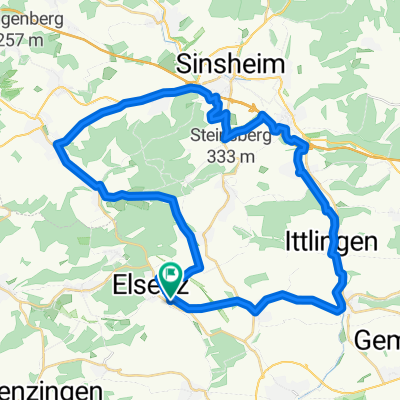
- Eppingen, Baden-Wurttemberg, Germany
A cycling route starting in Eppingen, Baden-Wurttemberg, Germany.
Overview
a route of the RadSportSenioren Rheinstetten.
the tram takes us to the starting point of the tour in Eppingen.
the following places are along the route: Mühlbach-Ochsenburg-Leonbronn-Sternenfels-Diefenbach-Zaisersweiher-Maulbronn-Knittlingen-Großvillars-Oberderdingen-Kürnbach-Sulzfeld-Zaisenhausen-Bahnbrücken-Menzingen-Landshausen-Rohrbach-Eppingen.
not yet cycled, target - summer/autumn 2009
created this 16 years ago
Route quality
Track
15 km
(24 %)
Road
12.5 km
(20 %)
Paved
38.8 km
(62 %)
Unpaved
6.9 km
(11 %)
Asphalt
31.9 km
(51 %)
Paved (undefined)
5.6 km
(9 %)
Route highlights
Einkehr lohnt sich hier im weingut Lutz, in der Stadtmitte am Amtshof.
Continue with Bikemap
You would like to ride RR von Eppingen zu den Schönheiten des Kraichgau or customize it for your own trip? Here is what you can do with this Bikemap route:
Free trial for 3 days, or one-time payment. More about Bikemap Premium.
Discover more Premium features.
Get Bikemap PremiumFrom our community
Open it in the app