

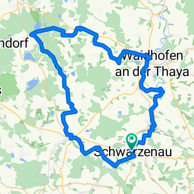
Schwarzenau - Drosendorf (Kamp-Thaya-March 1)
A cycling route starting in Schwarzenau, Lower Austria, Austria.
Overview
About this route
Stage 1 of the Kamp-Thaya-March cycle path
Schwarzenau - Drosendorf
- -:--
- Duration
- 64.6 km
- Distance
- 460 m
- Ascent
- 583 m
- Descent
- ---
- Avg. speed
- ---
- Max. altitude

Route quality
Waytypes & surfaces along the route
Waytypes
Road
34.9 km
(54 %)
Quiet road
16.2 km
(25 %)
Surfaces
Paved
18.7 km
(29 %)
Unpaved
3.2 km
(5 %)
Asphalt
16.8 km
(26 %)
Unpaved (undefined)
3.2 km
(5 %)
Continue with Bikemap
Use, edit, or download this cycling route
You would like to ride Schwarzenau - Drosendorf (Kamp-Thaya-March 1) or customize it for your own trip? Here is what you can do with this Bikemap route:
Free features
- Save this route as favorite or in collections
- Copy & plan your own version of this route
- Sync your route with Garmin or Wahoo
Premium features
Free trial for 3 days, or one-time payment. More about Bikemap Premium.
- Navigate this route on iOS & Android
- Export a GPX / KML file of this route
- Create your custom printout (try it for free)
- Download this route for offline navigation
Discover more Premium features.
Get Bikemap PremiumFrom our community
Other popular routes starting in Schwarzenau
 Schwarzenau - Melk 2021
- Distance
- 99.8 km
- Ascent
- 828 m
- Descent
- 1,103 m
- Location
- Schwarzenau, Lower Austria, Austria
 Thayarunde Sommer 2017
- Distance
- 105.5 km
- Ascent
- 552 m
- Descent
- 794 m
- Location
- Schwarzenau, Lower Austria, Austria
 Schwarzenau - Drosendorf (Kamp-Thaya-March 1)
- Distance
- 64.6 km
- Ascent
- 460 m
- Descent
- 583 m
- Location
- Schwarzenau, Lower Austria, Austria
 Teiche Radroute
- Distance
- 51.1 km
- Ascent
- 422 m
- Descent
- 473 m
- Location
- Schwarzenau, Lower Austria, Austria
 Schwarzenau - Rastenfeld Thaya-Kamp
- Distance
- 48 km
- Ascent
- 603 m
- Descent
- 627 m
- Location
- Schwarzenau, Lower Austria, Austria
 1. Tag - Kamp - Thaya - March - Radtour
- Distance
- 60.3 km
- Ascent
- 410 m
- Descent
- 509 m
- Location
- Schwarzenau, Lower Austria, Austria
 Thayatal Schwarzenau nach Retz
- Distance
- 115.5 km
- Ascent
- 744 m
- Descent
- 981 m
- Location
- Schwarzenau, Lower Austria, Austria
 Schwarzenau - Weitersfeld
- Distance
- 53.6 km
- Ascent
- 484 m
- Descent
- 556 m
- Location
- Schwarzenau, Lower Austria, Austria
Open it in the app