

Quatre Ports per la Nevera
A cycling route starting in La Pobla de Vallbona, Valencia, Spain.
Overview
About this route
Pobla - Pico del Águila - Vall de Almonacid - Aín - Eslida - Chovar - Oronet - Bétera - La Pobla
- -:--
- Duration
- 139.3 km
- Distance
- 1,569 m
- Ascent
- 1,561 m
- Descent
- ---
- Avg. speed
- ---
- Max. altitude

Route quality
Waytypes & surfaces along the route
Waytypes
Quiet road
18.1 km
(13 %)
Road
15.3 km
(11 %)
Surfaces
Paved
11.1 km
(8 %)
Unpaved
5.6 km
(4 %)
Asphalt
8.4 km
(6 %)
Gravel
4.2 km
(3 %)
Continue with Bikemap
Use, edit, or download this cycling route
You would like to ride Quatre Ports per la Nevera or customize it for your own trip? Here is what you can do with this Bikemap route:
Free features
- Save this route as favorite or in collections
- Copy & plan your own version of this route
- Split it into stages to create a multi-day tour
- Sync your route with Garmin or Wahoo
Premium features
Free trial for 3 days, or one-time payment. More about Bikemap Premium.
- Navigate this route on iOS & Android
- Export a GPX / KML file of this route
- Create your custom printout (try it for free)
- Download this route for offline navigation
Discover more Premium features.
Get Bikemap PremiumFrom our community
Other popular routes starting in La Pobla de Vallbona
 Geldo
Geldo- Distance
- 105.5 km
- Ascent
- 723 m
- Descent
- 714 m
- Location
- La Pobla de Vallbona, Valencia, Spain
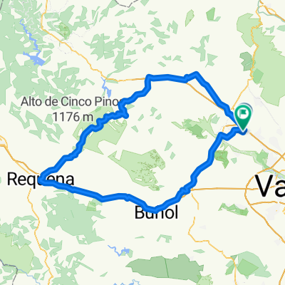 Pobla - Requena
- Distance
- 142.4 km
- Ascent
- 1,189 m
- Descent
- 1,201 m
- Location
- La Pobla de Vallbona, Valencia, Spain
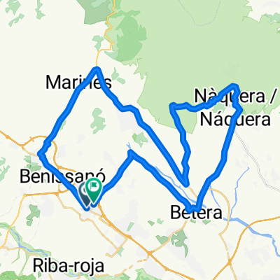
 Pedralba per Xest, tornar per Marines- La Torre
- Distance
- 76.3 km
- Ascent
- 436 m
- Descent
- 425 m
- Location
- La Pobla de Vallbona, Valencia, Spain
 Dos Aigües
- Distance
- 124.8 km
- Ascent
- 1,041 m
- Descent
- 1,041 m
- Location
- La Pobla de Vallbona, Valencia, Spain
 Quatre Ports per la Nevera
- Distance
- 139.3 km
- Ascent
- 1,569 m
- Descent
- 1,561 m
- Location
- La Pobla de Vallbona, Valencia, Spain
 Domenyo per Benaguasil-Pedralba-Casinos
- Distance
- 67.7 km
- Ascent
- 399 m
- Descent
- 389 m
- Location
- La Pobla de Vallbona, Valencia, Spain
 Serra per Llíria i Canteres
- Distance
- 59.7 km
- Ascent
- 440 m
- Descent
- 431 m
- Location
- La Pobla de Vallbona, Valencia, Spain
 Pedralba - Villar - Alcubles (CTRA. LLOSA-VILLAR EN OBRES)
- Distance
- 79.7 km
- Ascent
- 781 m
- Descent
- 779 m
- Location
- La Pobla de Vallbona, Valencia, Spain
Open it in the app