

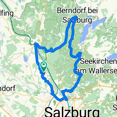
Gaisberg über Faistenau
A cycling route starting in Anthering, Salzburg, Austria.
Overview
About this route
through Salzburg, first flat upstream along the Salzach, then in Glasenbach towards the southern flank of the Gaisberg, leaving the Wiestal reservoir to the right and through the Strubklamm to Faistenau, a loop towards Zwölferhorn, then back over Ebenau to the final ascent to the Gaisberg
- -:--
- Duration
- 112.6 km
- Distance
- 1,460 m
- Ascent
- 1,460 m
- Descent
- ---
- Avg. speed
- ---
- Max. altitude

Route quality
Waytypes & surfaces along the route
Waytypes
Quiet road
39.4 km
(35 %)
Road
33.8 km
(30 %)
Surfaces
Paved
65.3 km
(58 %)
Unpaved
4.5 km
(4 %)
Asphalt
65.3 km
(58 %)
Gravel
3.4 km
(3 %)
Continue with Bikemap
Use, edit, or download this cycling route
You would like to ride Gaisberg über Faistenau or customize it for your own trip? Here is what you can do with this Bikemap route:
Free features
- Save this route as favorite or in collections
- Copy & plan your own version of this route
- Split it into stages to create a multi-day tour
- Sync your route with Garmin or Wahoo
Premium features
Free trial for 3 days, or one-time payment. More about Bikemap Premium.
- Navigate this route on iOS & Android
- Export a GPX / KML file of this route
- Create your custom printout (try it for free)
- Download this route for offline navigation
Discover more Premium features.
Get Bikemap PremiumFrom our community
Other popular routes starting in Anthering
 Anthering-Glocknerrunde
- Distance
- 319.8 km
- Ascent
- 3,726 m
- Descent
- 3,743 m
- Location
- Anthering, Salzburg, Austria
 Haunsberg-Högl-Runde
- Distance
- 86.1 km
- Ascent
- 984 m
- Descent
- 984 m
- Location
- Anthering, Salzburg, Austria
 SM7b Anthering - Laufen
- Distance
- 10.1 km
- Ascent
- 42 m
- Descent
- 68 m
- Location
- Anthering, Salzburg, Austria
 Eugendorf - Seekirchen - Wallersee - Mattsee - Berndorf - Nußdorf - Anthering
- Distance
- 69.9 km
- Ascent
- 668 m
- Descent
- 674 m
- Location
- Anthering, Salzburg, Austria
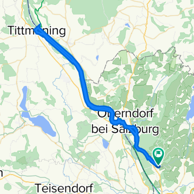 Anthering an der Salzach nach Tittmoning
- Distance
- 64.5 km
- Ascent
- 117 m
- Descent
- 117 m
- Location
- Anthering, Salzburg, Austria
 Gaisberg über Faistenau
- Distance
- 112.6 km
- Ascent
- 1,460 m
- Descent
- 1,460 m
- Location
- Anthering, Salzburg, Austria
 Himmelreich - Haunsberg - Berndorf - Elixhausen - Salzburg - Himmelreich
- Distance
- 64.2 km
- Ascent
- 669 m
- Descent
- 664 m
- Location
- Anthering, Salzburg, Austria
 Anthering-Surheim Runde
- Distance
- 35.7 km
- Ascent
- 136 m
- Descent
- 153 m
- Location
- Anthering, Salzburg, Austria
Open it in the app