

Abendrunde auf der Seiser Alm
A cycling route starting in Urtijëi, Trentino-Alto Adige, Italy.
Overview
About this route
DIe Route startet an der "Schgaguler" Schwaige/Malga bzw. an der Unterkunft "Almblick", führt über Schotter zur Bergstation der Kabinenbahn St. Ulrich und geht weiter über den Wanderweg 6S (offiziell für Radfahrer gesperrt...sollte man sich tagsüber dran halten..), anschließend in Wellen über die Asphaltstraße ein Stück zurück, rechts runter Richtung Schwaige "Sanon"... dann links über Wiesenweg und anschließend ab Hotel Sonne über Schotter/Asphalt ein paar Höhenmeter hinauf zurück.
Einkehren kann man nett an der Schwaige Sanon, aber auch bei der Schgaguler Schwaige - allerdings gibts hier nur bis etwa 17:00 was auf die Gabel. Hier kann man übrigens auch Käse, Milch etc. direkt vom Bergbauernhof abkaufen. Wer noch die Kabinenbah nach ST. Ulrich erwischen muss: die fährt bis 17:00 Uhr.
Etwa 200 hm auf knapp 2000hm :-)
- -:--
- Duration
- 5.3 km
- Distance
- 262 m
- Ascent
- 262 m
- Descent
- ---
- Avg. speed
- ---
- Avg. speed
Continue with Bikemap
Use, edit, or download this cycling route
You would like to ride Abendrunde auf der Seiser Alm or customize it for your own trip? Here is what you can do with this Bikemap route:
Free features
- Save this route as favorite or in collections
- Copy & plan your own version of this route
- Sync your route with Garmin or Wahoo
Premium features
Free trial for 3 days, or one-time payment. More about Bikemap Premium.
- Navigate this route on iOS & Android
- Export a GPX / KML file of this route
- Create your custom printout (try it for free)
- Download this route for offline navigation
Discover more Premium features.
Get Bikemap PremiumFrom our community
Other popular routes starting in Urtijëi
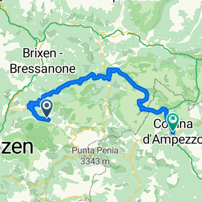 Streda Sneton, Ortisei to Via Guglielmo Marconi, Cortina d'Ampezzo
- Distance
- 102.7 km
- Ascent
- 5,133 m
- Descent
- 5,144 m
- Location
- Urtijëi, Trentino-Alto Adige, Italy
 tour 190713 seiseralm
- Distance
- 38.8 km
- Ascent
- 1,248 m
- Descent
- 1,250 m
- Location
- Urtijëi, Trentino-Alto Adige, Italy
 SellaRondaBikeDay
- Distance
- 79.6 km
- Ascent
- 2,237 m
- Descent
- 2,240 m
- Location
- Urtijëi, Trentino-Alto Adige, Italy
 Plattkofelrunde ohne
- Distance
- 22.9 km
- Ascent
- 893 m
- Descent
- 893 m
- Location
- Urtijëi, Trentino-Alto Adige, Italy
 Sull'Alpe di Siusi tra malghe, masi e alpeggi
- Distance
- 25.5 km
- Ascent
- 632 m
- Descent
- 629 m
- Location
- Urtijëi, Trentino-Alto Adige, Italy
 AanloopErbe
- Distance
- 21.2 km
- Ascent
- 63 m
- Descent
- 828 m
- Location
- Urtijëi, Trentino-Alto Adige, Italy
 St. Ulrich - Saltria - Pufls - St. Ulrich
- Distance
- 20.6 km
- Ascent
- 901 m
- Descent
- 904 m
- Location
- Urtijëi, Trentino-Alto Adige, Italy
 ValG_SellaClock
- Distance
- 67.3 km
- Ascent
- 1,032 m
- Descent
- 2,342 m
- Location
- Urtijëi, Trentino-Alto Adige, Italy
Open it in the app