

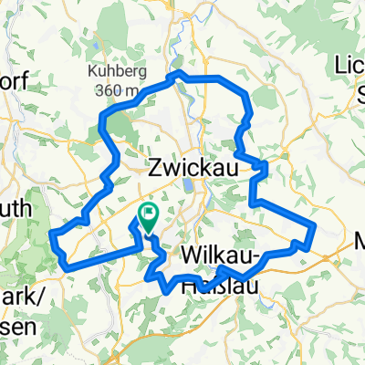
Thanhof-Kirchberg-Eibenstock-Auerbach-Lengenfeld-Gospersgrün
A cycling route starting in Lichtentanne, Saxony, Germany.
Overview
About this route
Thanhof-Schönfels über Lieberg-Hirschfeld-Kirchberg-
über Torfstraße Richtung Eibenstock- B283: Morgenröthe Rautenkranz- bis Jägersgrün Auerbach-Rodewisch B94: bis Lengenfeld Irfersgrün-Schönfels-Gospersgrün-Anstieg nach Thanhof- -:--
- Duration
- 87.6 km
- Distance
- 786 m
- Ascent
- 786 m
- Descent
- ---
- Avg. speed
- ---
- Max. altitude

Route quality
Waytypes & surfaces along the route
Waytypes
Busy road
54.7 km
(62 %)
Quiet road
13.7 km
(16 %)
Surfaces
Paved
58.6 km
(67 %)
Unpaved
0 km
(<1 %)
Asphalt
58.4 km
(67 %)
Paved (undefined)
0.1 km
(<1 %)
Continue with Bikemap
Use, edit, or download this cycling route
You would like to ride Thanhof-Kirchberg-Eibenstock-Auerbach-Lengenfeld-Gospersgrün or customize it for your own trip? Here is what you can do with this Bikemap route:
Free features
- Save this route as favorite or in collections
- Copy & plan your own version of this route
- Split it into stages to create a multi-day tour
- Sync your route with Garmin or Wahoo
Premium features
Free trial for 3 days, or one-time payment. More about Bikemap Premium.
- Navigate this route on iOS & Android
- Export a GPX / KML file of this route
- Create your custom printout (try it for free)
- Download this route for offline navigation
Discover more Premium features.
Get Bikemap PremiumFrom our community
Other popular routes starting in Lichtentanne
 Marienthal - Niederschindmaas
- Distance
- 18.4 km
- Ascent
- 0 m
- Descent
- 79 m
- Location
- Lichtentanne, Saxony, Germany
 Zwickau/Planitz - Mülsengrund und zurück
- Distance
- 40.1 km
- Ascent
- 258 m
- Descent
- 304 m
- Location
- Lichtentanne, Saxony, Germany
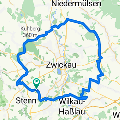
 Rund um Zwickau
- Distance
- 49.9 km
- Ascent
- 547 m
- Descent
- 547 m
- Location
- Lichtentanne, Saxony, Germany
 Huegelig Kirchberg Niedercrinitz Rottmannsdorf
- Distance
- 35.7 km
- Ascent
- 542 m
- Descent
- 542 m
- Location
- Lichtentanne, Saxony, Germany
 Thanhof-Kirchberg-Eibenstock-Auerbach-Lengenfeld-Gospersgrün
- Distance
- 87.6 km
- Ascent
- 786 m
- Descent
- 786 m
- Location
- Lichtentanne, Saxony, Germany
 Waldkirchen Tourplan
- Distance
- 36.8 km
- Ascent
- 439 m
- Descent
- 439 m
- Location
- Lichtentanne, Saxony, Germany
 Rund um Zwickau ( Kl. Runde )
- Distance
- 39.2 km
- Ascent
- 422 m
- Descent
- 426 m
- Location
- Lichtentanne, Saxony, Germany
 Thanhof-Schmölln-Lucka-Leipzig
- Distance
- 83.9 km
- Ascent
- 167 m
- Descent
- 403 m
- Location
- Lichtentanne, Saxony, Germany
Open it in the app