

20130509_Lenninger Tal Bad Urach
A cycling route starting in Owen, Baden-Wurttemberg, Germany.
Overview
About this route
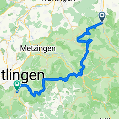
From the Tiefenbach valley via the Lenninge valley to Bad Urach and back
- -:--
- Duration
- 68.1 km
- Distance
- 1,379 m
- Ascent
- 1,379 m
- Descent
- ---
- Avg. speed
- ---
- Max. altitude
Continue with Bikemap
Use, edit, or download this cycling route
You would like to ride 20130509_Lenninger Tal Bad Urach or customize it for your own trip? Here is what you can do with this Bikemap route:
Free features
- Save this route as favorite or in collections
- Copy & plan your own version of this route
- Sync your route with Garmin or Wahoo
Premium features
Free trial for 3 days, or one-time payment. More about Bikemap Premium.
- Navigate this route on iOS & Android
- Export a GPX / KML file of this route
- Create your custom printout (try it for free)
- Download this route for offline navigation
Discover more Premium features.
Get Bikemap PremiumFrom our community
Other popular routes starting in Owen
 Burg Teck nach Bissingen Adler
- Distance
- 3.9 km
- Ascent
- 6 m
- Descent
- 352 m
- Location
- Owen, Baden-Wurttemberg, Germany
 rund ums lenningen
- Distance
- 54.4 km
- Ascent
- 1,224 m
- Descent
- 1,224 m
- Location
- Owen, Baden-Wurttemberg, Germany
 20130509_Lenninger Tal Bad Urach
- Distance
- 68.1 km
- Ascent
- 1,379 m
- Descent
- 1,379 m
- Location
- Owen, Baden-Wurttemberg, Germany
 DreiStoigaTour
- Distance
- 41.3 km
- Ascent
- 940 m
- Descent
- 943 m
- Location
- Owen, Baden-Wurttemberg, Germany
 Owen-Käppele-Bürgersee-Bushaltest. Dettingen
- Distance
- 11.7 km
- Ascent
- 199 m
- Descent
- 238 m
- Location
- Owen, Baden-Wurttemberg, Germany
 Biosphärengastgeber-Tour: Albtrauftour
- Distance
- 55.8 km
- Ascent
- 1,039 m
- Descent
- 1,039 m
- Location
- Owen, Baden-Wurttemberg, Germany
 Feierabendtour-E-Weiler rund um den Hohen Neuffen
- Distance
- 22 km
- Ascent
- 670 m
- Descent
- 672 m
- Location
- Owen, Baden-Wurttemberg, Germany
 Alp Cross - 4
- Distance
- 41.9 km
- Ascent
- 942 m
- Descent
- 902 m
- Location
- Owen, Baden-Wurttemberg, Germany
Open it in the app