
unternogg
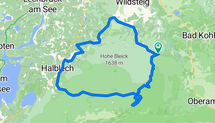
A cycling route starting in Saulgrub, Bavaria, Germany.
Overview
About this route
- -:--
- Duration
- 43.5 km
- Distance
- 784 m
- Ascent
- 578 m
- Descent
- ---
- Avg. speed
- 1,123 m
- Max. altitude
Route quality
Waytypes & surfaces along the route
Waytypes
Track
32.5 km
(75 %)
Quiet road
9.7 km
(22 %)
Surfaces
Paved
13 km
(30 %)
Unpaved
28.6 km
(66 %)
Gravel
24.2 km
(56 %)
Asphalt
12.7 km
(29 %)
Continue with Bikemap
Use, edit, or download this cycling route
You would like to ride unternogg or customize it for your own trip? Here is what you can do with this Bikemap route:
Free features
- Save this route as favorite or in collections
- Copy & plan your own version of this route
- Sync your route with Garmin or Wahoo
Premium features
Free trial for 3 days, or one-time payment. More about Bikemap Premium.
- Navigate this route on iOS & Android
- Export a GPX / KML file of this route
- Create your custom printout (try it for free)
- Download this route for offline navigation
Discover more Premium features.
Get Bikemap PremiumFrom our community
Other popular routes starting in Saulgrub
 Soienersee - Staffelsee
- Distance
- 39.8 km
- Ascent
- 447 m
- Descent
- 461 m
- Location
- Saulgrub, Bavaria, Germany
 4. Etappe Saulgrub - Bad Tölz (Bodensee-Königssee-Radweg)
- Distance
- 61.3 km
- Ascent
- 338 m
- Descent
- 538 m
- Location
- Saulgrub, Bavaria, Germany
 unternogg
- Distance
- 43.5 km
- Ascent
- 784 m
- Descent
- 578 m
- Location
- Saulgrub, Bavaria, Germany
 Soierensee-Staffelsee
- Distance
- 38.3 km
- Ascent
- 457 m
- Descent
- 464 m
- Location
- Saulgrub, Bavaria, Germany
 Ammergebirge-Rundfahrt
- Distance
- 105.6 km
- Ascent
- 601 m
- Descent
- 601 m
- Location
- Saulgrub, Bavaria, Germany
 Soinersee-Deutensee přes Wildsteig
- Distance
- 39.9 km
- Ascent
- 334 m
- Descent
- 336 m
- Location
- Saulgrub, Bavaria, Germany
 Soinersee-Deutensee přes Wildsteig
- Distance
- 40 km
- Ascent
- 335 m
- Descent
- 337 m
- Location
- Saulgrub, Bavaria, Germany
 Ammer Amper Radweg_lang
- Distance
- 99.5 km
- Ascent
- 399 m
- Descent
- 1,245 m
- Location
- Saulgrub, Bavaria, Germany
Open it in the app