
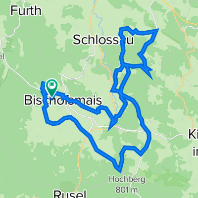
Fressendes Haus Nr. 21
A cycling route starting in Bischofsmais, Bavaria, Germany.
Overview
About this route
The tour starts in Bischofsmais at the parking lot on the main road. Via Wastlsäg, Sankt Hermann, and Kleinbärnbach, we go down to Stegwiese in the valley of Kleinbärnbach. The next section of the tour takes us uphill through Ritzmais and Kühberg to Seiboldsried, before we can roll the bike back down to Fichtenbach. After a small climb over Ottenberg, we continue downhill via Zell to the valley of Schlossauer Ohe. The next ascent takes us through Großseiboldsried to Kleinseiboldsried. We now ride a loop through Weißenstein and Matzelsried down to the next stream, the Pfaffenbach, and back to Großseiboldsried. From there, we proceed to Langbruck and at Birkenthal cross the Schlossauer Ohe. Via Kaltenbrunn and Hochdorf, we return back to the starting point in Bischofsmais.
- -:--
- Duration
- 31.7 km
- Distance
- 693 m
- Ascent
- 693 m
- Descent
- ---
- Avg. speed
- ---
- Max. altitude

Route quality
Waytypes & surfaces along the route
Waytypes
Track
18.7 km
(59 %)
Quiet road
7.6 km
(24 %)
Surfaces
Paved
4.4 km
(14 %)
Unpaved
8.9 km
(28 %)
Ground
5.1 km
(16 %)
Asphalt
4.4 km
(14 %)
Continue with Bikemap
Use, edit, or download this cycling route
You would like to ride Fressendes Haus Nr. 21 or customize it for your own trip? Here is what you can do with this Bikemap route:
Free features
- Save this route as favorite or in collections
- Copy & plan your own version of this route
- Sync your route with Garmin or Wahoo
Premium features
Free trial for 3 days, or one-time payment. More about Bikemap Premium.
- Navigate this route on iOS & Android
- Export a GPX / KML file of this route
- Create your custom printout (try it for free)
- Download this route for offline navigation
Discover more Premium features.
Get Bikemap PremiumFrom our community
Other popular routes starting in Bischofsmais
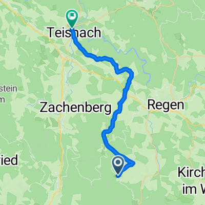 Hermannsried-Teisnach
- Distance
- 23.6 km
- Ascent
- 355 m
- Descent
- 704 m
- Location
- Bischofsmais, Bavaria, Germany
 Geißkopf - Landshuter Haus - Wanderweg Nummer 3
- Distance
- 20.4 km
- Ascent
- 527 m
- Descent
- 527 m
- Location
- Bischofsmais, Bavaria, Germany
 Fressendes_Haus_Nr._21
- Distance
- 31.7 km
- Ascent
- 855 m
- Descent
- 858 m
- Location
- Bischofsmais, Bavaria, Germany
 Bischofsmais - Regen - Bodenmais - Bischofsmais
- Distance
- 52.4 km
- Ascent
- 681 m
- Descent
- 678 m
- Location
- Bischofsmais, Bavaria, Germany
 dürrwies-gaiskopf-dürrwies
- Distance
- 22.1 km
- Ascent
- 475 m
- Descent
- 468 m
- Location
- Bischofsmais, Bavaria, Germany
 Fressendes Haus Nr. 21
- Distance
- 31.7 km
- Ascent
- 693 m
- Descent
- 693 m
- Location
- Bischofsmais, Bavaria, Germany
 Trans_Bayerwald_Sd_Etappe_6_Bischofsmais_-_Eging_am_See
- Distance
- 63.5 km
- Ascent
- 1,944 m
- Descent
- 2,224 m
- Location
- Bischofsmais, Bavaria, Germany
 MTB KIds Tour
- Distance
- 13.6 km
- Ascent
- 657 m
- Descent
- 657 m
- Location
- Bischofsmais, Bavaria, Germany
Open it in the app