

Walnut Grove to Abbotsford and Fort Langley
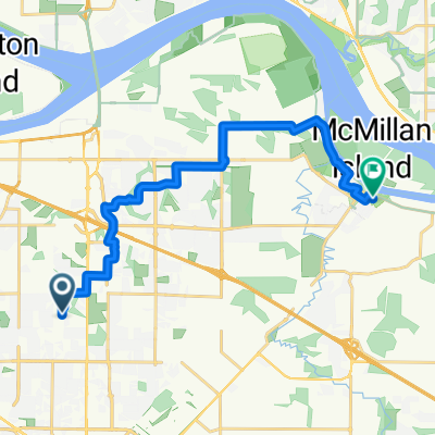
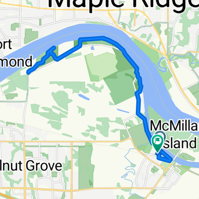
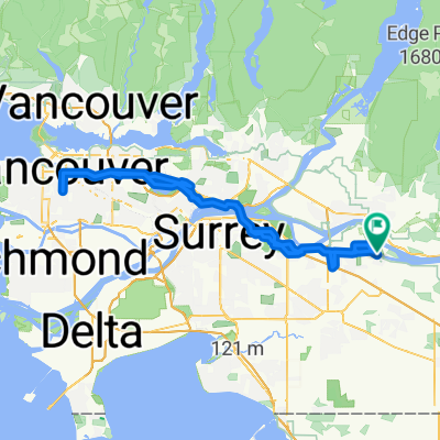
A cycling route starting in Walnut Grove, British Columbia, Canada.
Overview
About this route
Beautiful route, lots of country scenery, some good hills and very little traffic.
- -:--
- Duration
- 57.7 km
- Distance
- 6,978 m
- Ascent
- 6,978 m
- Descent
- ---
- Avg. speed
- ---
- Max. altitude
Route quality
Waytypes & surfaces along the route
Waytypes
Road
33.5 km
(58 %)
Quiet road
7.5 km
(13 %)
Undefined
16.7 km
(29 %)
Surfaces
Paved
26 km
(45 %)
Asphalt
24.2 km
(42 %)
Paved (undefined)
1.7 km
(3 %)
Undefined
31.7 km
(55 %)
Continue with Bikemap
Use, edit, or download this cycling route
You would like to ride Walnut Grove to Abbotsford and Fort Langley or customize it for your own trip? Here is what you can do with this Bikemap route:
Free features
- Save this route as favorite or in collections
- Copy & plan your own version of this route
- Sync your route with Garmin or Wahoo
Premium features
Free trial for 3 days, or one-time payment. More about Bikemap Premium.
- Navigate this route on iOS & Android
- Export a GPX / KML file of this route
- Create your custom printout (try it for free)
- Download this route for offline navigation
Discover more Premium features.
Get Bikemap PremiumFrom our community
Other popular routes starting in Walnut Grove
 asdfl'
- Distance
- 14.9 km
- Ascent
- 82 m
- Descent
- 137 m
- Location
- Walnut Grove, British Columbia, Canada
 Fort Langley to Pitt Meadows Loop
- Distance
- 54 km
- Ascent
- 156 m
- Descent
- 133 m
- Location
- Walnut Grove, British Columbia, Canada
 Hike Yorkson Dog Park and Willoughby Trail Langley 5 km
- Distance
- 5.3 km
- Ascent
- 27 m
- Descent
- 24 m
- Location
- Walnut Grove, British Columbia, Canada
 102KM- summer 2025
- Distance
- 98.6 km
- Ascent
- 918 m
- Descent
- 915 m
- Location
- Walnut Grove, British Columbia, Canada
 Fort Langley to Glenn Valley
- Distance
- 26.7 km
- Ascent
- 123 m
- Descent
- 119 m
- Location
- Walnut Grove, British Columbia, Canada
 Bumpy Distance route
- Distance
- 67.4 km
- Ascent
- 279 m
- Descent
- 280 m
- Location
- Walnut Grove, British Columbia, Canada
 Fort-to-Fort Trail
- Distance
- 18.6 km
- Ascent
- 43 m
- Descent
- 48 m
- Location
- Walnut Grove, British Columbia, Canada
 Watch the ‘Cs’ at the Nat
- Distance
- 124.6 km
- Ascent
- 785 m
- Descent
- 786 m
- Location
- Walnut Grove, British Columbia, Canada
Open it in the app