
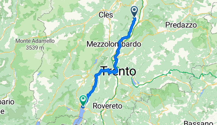
neumarkt Riva del Garda
A cycling route starting in Termeno, Trentino-Alto Adige, Italy.
Overview
About this route
letzte Etappe der Tour
- -:--
- Duration
- 92.2 km
- Distance
- 1,299 m
- Ascent
- 1,243 m
- Descent
- ---
- Avg. speed
- 820 m
- Max. altitude
Route quality
Waytypes & surfaces along the route
Waytypes
Road
26.8 km
(29 %)
Quiet road
24.9 km
(27 %)
Surfaces
Paved
69.1 km
(75 %)
Unpaved
7.8 km
(8 %)
Asphalt
69.1 km
(75 %)
Ground
6.6 km
(7 %)
Continue with Bikemap
Use, edit, or download this cycling route
You would like to ride neumarkt Riva del Garda or customize it for your own trip? Here is what you can do with this Bikemap route:
Free features
- Save this route as favorite or in collections
- Copy & plan your own version of this route
- Split it into stages to create a multi-day tour
- Sync your route with Garmin or Wahoo
Premium features
Free trial for 3 days, or one-time payment. More about Bikemap Premium.
- Navigate this route on iOS & Android
- Export a GPX / KML file of this route
- Create your custom printout (try it for free)
- Download this route for offline navigation
Discover more Premium features.
Get Bikemap PremiumFrom our community
Other popular routes starting in Termeno
 Traminer Hof - Zur Brücke
- Distance
- 14 km
- Ascent
- 19 m
- Descent
- 56 m
- Location
- Termeno, Trentino-Alto Adige, Italy
 RSCN - Tramin - Lavis - Altrei - Auer
- Distance
- 96.3 km
- Ascent
- 1,221 m
- Descent
- 1,221 m
- Location
- Termeno, Trentino-Alto Adige, Italy
 Auffahrt zum Lenzenhof
- Distance
- 7.9 km
- Ascent
- 591 m
- Descent
- 76 m
- Location
- Termeno, Trentino-Alto Adige, Italy
 bozen (weinstrasse)
- Distance
- 71.2 km
- Ascent
- 416 m
- Descent
- 420 m
- Location
- Termeno, Trentino-Alto Adige, Italy
 Grauner Joch Südtirol
- Distance
- 33.7 km
- Ascent
- 1,898 m
- Descent
- 1,898 m
- Location
- Termeno, Trentino-Alto Adige, Italy
 Mendelrunde
- Distance
- 107.6 km
- Ascent
- 2,250 m
- Descent
- 2,279 m
- Location
- Termeno, Trentino-Alto Adige, Italy
 Tramin-Gampenpass-Mendelpass
- Distance
- 107.7 km
- Ascent
- 1,861 m
- Descent
- 1,861 m
- Location
- Termeno, Trentino-Alto Adige, Italy
 neumarkt Riva del Garda
- Distance
- 92.2 km
- Ascent
- 1,299 m
- Descent
- 1,243 m
- Location
- Termeno, Trentino-Alto Adige, Italy
Open it in the app