

Geocaching Montoz
A cycling route starting in Tavannes, Canton of Bern, Switzerland.
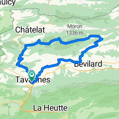
Overview
About this route
Petit parcours avec géocache aux alentours.
Les points d'intérêts sont les caches disponibles- -:--
- Duration
- 31.1 km
- Distance
- 934 m
- Ascent
- 933 m
- Descent
- ---
- Avg. speed
- ---
- Max. altitude
Route quality
Waytypes & surfaces along the route
Waytypes
Track
17.9 km
(57 %)
Busy road
7.3 km
(23 %)
Surfaces
Paved
6.5 km
(21 %)
Unpaved
17.3 km
(56 %)
Gravel
9.7 km
(31 %)
Unpaved (undefined)
7.2 km
(23 %)
Route highlights
Points of interest along the route
Point of interest after 4.6 km
La grotte du Brahon
Point of interest after 5.2 km
Le sentier de la crête
Continue with Bikemap
Use, edit, or download this cycling route
You would like to ride Geocaching Montoz or customize it for your own trip? Here is what you can do with this Bikemap route:
Free features
- Save this route as favorite or in collections
- Copy & plan your own version of this route
- Sync your route with Garmin or Wahoo
Premium features
Free trial for 3 days, or one-time payment. More about Bikemap Premium.
- Navigate this route on iOS & Android
- Export a GPX / KML file of this route
- Create your custom printout (try it for free)
- Download this route for offline navigation
Discover more Premium features.
Get Bikemap PremiumFrom our community
Other popular routes starting in Tavannes
 France mont.
- Distance
- 44.1 km
- Ascent
- 1,397 m
- Descent
- 1,399 m
- Location
- Tavannes, Canton of Bern, Switzerland
 Franches Montagnes à vélo
- Distance
- 42.7 km
- Ascent
- 734 m
- Descent
- 726 m
- Location
- Tavannes, Canton of Bern, Switzerland
 tavannes-goumois
- Distance
- 28.2 km
- Ascent
- 550 m
- Descent
- 753 m
- Location
- Tavannes, Canton of Bern, Switzerland
 Boucle via Moron de 30 km
- Distance
- 29.1 km
- Ascent
- 707 m
- Descent
- 715 m
- Location
- Tavannes, Canton of Bern, Switzerland
 Moutier et3
- Distance
- 86.2 km
- Ascent
- 1,583 m
- Descent
- 1,585 m
- Location
- Tavannes, Canton of Bern, Switzerland
 Geocaching Montoz
- Distance
- 31.1 km
- Ascent
- 934 m
- Descent
- 933 m
- Location
- Tavannes, Canton of Bern, Switzerland
 MTB862
- Distance
- 29.7 km
- Ascent
- 1,044 m
- Descent
- 1,043 m
- Location
- Tavannes, Canton of Bern, Switzerland
 Rue de la Gare 2, Tavannes nach Rue de l'Avenir 14, Delsberg
- Distance
- 31.4 km
- Ascent
- 375 m
- Descent
- 718 m
- Location
- Tavannes, Canton of Bern, Switzerland
Open it in the app