

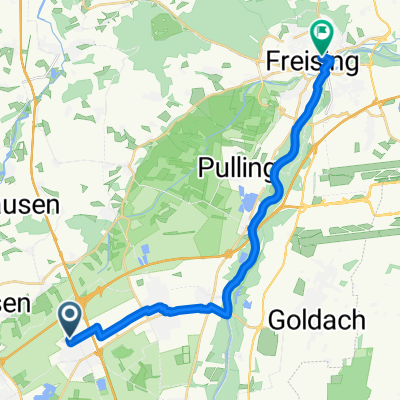
Eching-Flughafen-Eching
A cycling route starting in Eching, Bavaria, Germany.
Overview
About this route
Eching-Airport-Eching
- -:--
- Duration
- 44.1 km
- Distance
- 24 m
- Ascent
- 26 m
- Descent
- ---
- Avg. speed
- ---
- Max. altitude
Route quality
Waytypes & surfaces along the route
Waytypes
Track
14.1 km
(32 %)
Path
14.1 km
(32 %)
Surfaces
Paved
27.4 km
(62 %)
Unpaved
13.2 km
(30 %)
Asphalt
26 km
(59 %)
Gravel
12.8 km
(29 %)
Continue with Bikemap
Use, edit, or download this cycling route
You would like to ride Eching-Flughafen-Eching or customize it for your own trip? Here is what you can do with this Bikemap route:
Free features
- Save this route as favorite or in collections
- Copy & plan your own version of this route
- Sync your route with Garmin or Wahoo
Premium features
Free trial for 3 days, or one-time payment. More about Bikemap Premium.
- Navigate this route on iOS & Android
- Export a GPX / KML file of this route
- Create your custom printout (try it for free)
- Download this route for offline navigation
Discover more Premium features.
Get Bikemap PremiumFrom our community
Other popular routes starting in Eching
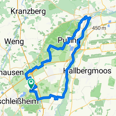
 Kleine Kranzberger Wald Runde
- Distance
- 41 km
- Ascent
- 170 m
- Descent
- 166 m
- Location
- Eching, Bavaria, Germany
 Kleine Kranzberger Wald Runde CLONED FROM ROUTE 467914
- Distance
- 41 km
- Ascent
- 170 m
- Descent
- 166 m
- Location
- Eching, Bavaria, Germany
 Freising
- Distance
- 19.8 km
- Ascent
- 0 m
- Descent
- 10 m
- Location
- Eching, Bavaria, Germany
 Eching - Moosmühle - Freising - Dietersheim - Eching
- Distance
- 47 km
- Ascent
- 179 m
- Descent
- 180 m
- Location
- Eching, Bavaria, Germany
 Eching-MarktIndersdorf-Altomünster-MarktIndersdorf-Petershausen-Eching
- Distance
- 77.8 km
- Ascent
- 256 m
- Descent
- 256 m
- Location
- Eching, Bavaria, Germany
 Eching - Amper Route Kurz
- Distance
- 35.8 km
- Ascent
- 64 m
- Descent
- 65 m
- Location
- Eching, Bavaria, Germany
 Von Eching zum Feringasee
- Distance
- 25.3 km
- Ascent
- 106 m
- Descent
- 82 m
- Location
- Eching, Bavaria, Germany
 hightadei_01/A-01
- Distance
- 75.4 km
- Ascent
- 261 m
- Descent
- 340 m
- Location
- Eching, Bavaria, Germany
Open it in the app