

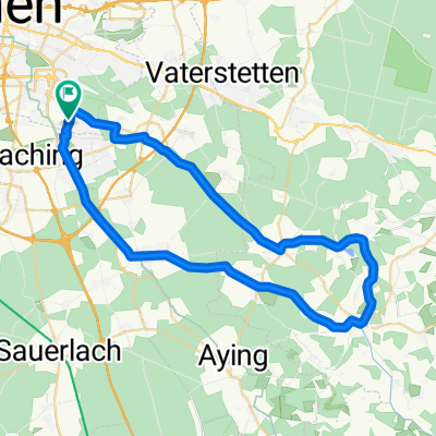
Trudering - Vagen (Mangfalltal) und zurück
A cycling route starting in Neubiberg, Bavaria, Germany.
Overview
About this route
Schöne Tour aus dem Münchner Osten raus in Richtung Süden ohne Hauptstrassen zu benutzen (im Gegensatz zum offiziellen Verlauf des Mangfalltalradwegs!) Ab Dürrnhaar dann dem Mangfalltalradweg folgen. Der Rückweg über Westerham un Kleinhöhenkirchen bietet nochmal zwei knackige Steigungen, danach viele Möglichkeiten "abzukürzen", da viele S-Bahnhöfe auf dem Weg. Ab Großhelfendorf rollt der müde Radler steigungsfrei heim nach München...
- -:--
- Duration
- 78.7 km
- Distance
- 506 m
- Ascent
- 469 m
- Descent
- ---
- Avg. speed
- 671 m
- Max. altitude
Route quality
Waytypes & surfaces along the route
Waytypes
Quiet road
38.6 km
(49 %)
Road
11.2 km
(14 %)
Surfaces
Paved
68.3 km
(87 %)
Unpaved
9 km
(11 %)
Asphalt
67.6 km
(86 %)
Loose gravel
3.3 km
(4 %)
Continue with Bikemap
Use, edit, or download this cycling route
You would like to ride Trudering - Vagen (Mangfalltal) und zurück or customize it for your own trip? Here is what you can do with this Bikemap route:
Free features
- Save this route as favorite or in collections
- Copy & plan your own version of this route
- Sync your route with Garmin or Wahoo
Premium features
Free trial for 3 days, or one-time payment. More about Bikemap Premium.
- Navigate this route on iOS & Android
- Export a GPX / KML file of this route
- Create your custom printout (try it for free)
- Download this route for offline navigation
Discover more Premium features.
Get Bikemap PremiumFrom our community
Other popular routes starting in Neubiberg
 Seentour - München Ost
- Distance
- 26.3 km
- Ascent
- 26 m
- Descent
- 24 m
- Location
- Neubiberg, Bavaria, Germany
 Route entlang der Isar und des Perlacher Forstes
- Distance
- 25.1 km
- Ascent
- 126 m
- Descent
- 126 m
- Location
- Neubiberg, Bavaria, Germany
 Kirchsee Tour
- Distance
- 95.8 km
- Ascent
- 585 m
- Descent
- 547 m
- Location
- Neubiberg, Bavaria, Germany
 Glonn
Glonn- Distance
- 49.1 km
- Ascent
- 551 m
- Descent
- 553 m
- Location
- Neubiberg, Bavaria, Germany
 THE WALTHERS Waldperlach - Isar Runde 01
- Distance
- 34.7 km
- Ascent
- 72 m
- Descent
- 73 m
- Location
- Neubiberg, Bavaria, Germany
 Aying 50 km
- Distance
- 51.3 km
- Ascent
- 246 m
- Descent
- 228 m
- Location
- Neubiberg, Bavaria, Germany
 Neuperlach - Solalinden
- Distance
- 12.2 km
- Ascent
- 73 m
- Descent
- 75 m
- Location
- Neubiberg, Bavaria, Germany
 Neubiberg-Leitzachtal-Irschenberg
- Distance
- 126.6 km
- Ascent
- 1,375 m
- Descent
- 1,372 m
- Location
- Neubiberg, Bavaria, Germany
Open it in the app