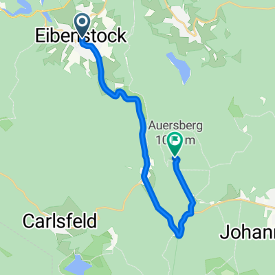
Rundtour Eibenstock-Riesenberger Häuser-Kammweg-Carlsfeld
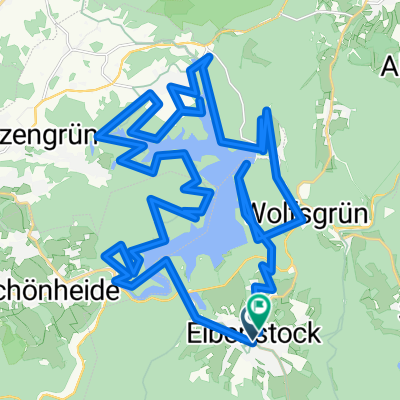
A cycling route starting in Eibenstock, Saxony, Germany.
Overview
About this route
Wunderschöne Rundtour im Westerzegebirge von Eibenstock über Talsperre Sosa-Riesenberger Häuser-Kammweg-Carlsfeld und zurück nach Eibenstock, geeignet für den fortgeschrittenen Mountainbiker.
- -:--
- Duration
- 33.7 km
- Distance
- 484 m
- Ascent
- 484 m
- Descent
- ---
- Avg. speed
- ---
- Avg. speed
Route quality
Waytypes & surfaces along the route
Waytypes
Track
28.7 km
(85 %)
Quiet road
2.9 km
(8 %)
Surfaces
Paved
12.4 km
(37 %)
Unpaved
17.7 km
(53 %)
Gravel
15.9 km
(47 %)
Asphalt
6.9 km
(20 %)
Continue with Bikemap
Use, edit, or download this cycling route
You would like to ride Rundtour Eibenstock-Riesenberger Häuser-Kammweg-Carlsfeld or customize it for your own trip? Here is what you can do with this Bikemap route:
Free features
- Save this route as favorite or in collections
- Copy & plan your own version of this route
- Sync your route with Garmin or Wahoo
Premium features
Free trial for 3 days, or one-time payment. More about Bikemap Premium.
- Navigate this route on iOS & Android
- Export a GPX / KML file of this route
- Create your custom printout (try it for free)
- Download this route for offline navigation
Discover more Premium features.
Get Bikemap PremiumFrom our community
Other popular routes starting in Eibenstock
- Drei-Talsperren-Marathon Eibenstock (30km)
- Distance
- 30.6 km
- Ascent
- 577 m
- Descent
- 574 m
- Location
- Eibenstock, Saxony, Germany
- Talsperre Eibenstock
- Distance
- 28 km
- Ascent
- 456 m
- Descent
- 451 m
- Location
- Eibenstock, Saxony, Germany
- Carlsfelder Hauptstraße 11, Eibenstock nach Carlsfeld, Hauptstr, Eibenstock
- Distance
- 10.4 km
- Ascent
- 228 m
- Descent
- 228 m
- Location
- Eibenstock, Saxony, Germany
- Eibenstock-Sosa-Eibenstock
- Distance
- 19.7 km
- Ascent
- 399 m
- Descent
- 390 m
- Location
- Eibenstock, Saxony, Germany
- rund um die Talsperre Eibenstock
- Distance
- 27 km
- Ascent
- 464 m
- Descent
- 464 m
- Location
- Eibenstock, Saxony, Germany
- Auersberg/ Tschechien/ Kammweg und zurück
- Distance
- 53.3 km
- Ascent
- 987 m
- Descent
- 986 m
- Location
- Eibenstock, Saxony, Germany
- Eibenstock-Blauenthaler Wasserfall-Auersberg-Carlsfeld
- Distance
- 36.4 km
- Ascent
- 743 m
- Descent
- 743 m
- Location
- Eibenstock, Saxony, Germany
- 20250520_Zwickauer_Mulde_Etappe 2
- Distance
- 47.1 km
- Ascent
- 517 m
- Descent
- 876 m
- Location
- Eibenstock, Saxony, Germany
Open it in the app