

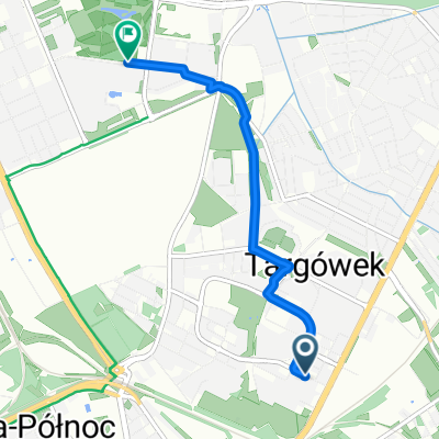
Warszawa-Modlin
A cycling route starting in Praga Północ, Masovian Voivodeship, Poland.
Overview
About this route
Start: Mermaid Monument near the Świętokrzyski Bridge
Destination: Modlin Fortress
Route 'consulted' with satellite/aerial images from the Zumi.pl service
- -:--
- Duration
- 40.6 km
- Distance
- 77 m
- Ascent
- 66 m
- Descent
- ---
- Avg. speed
- ---
- Max. altitude

Continue with Bikemap
Use, edit, or download this cycling route
You would like to ride Warszawa-Modlin or customize it for your own trip? Here is what you can do with this Bikemap route:
Free features
- Save this route as favorite or in collections
- Copy & plan your own version of this route
- Sync your route with Garmin or Wahoo
Premium features
Free trial for 3 days, or one-time payment. More about Bikemap Premium.
- Navigate this route on iOS & Android
- Export a GPX / KML file of this route
- Create your custom printout (try it for free)
- Download this route for offline navigation
Discover more Premium features.
Get Bikemap PremiumFrom our community
Other popular routes starting in Praga Północ
 po nurka
- Distance
- 33.3 km
- Ascent
- 45 m
- Descent
- 45 m
- Location
- Praga Północ, Masovian Voivodeship, Poland
 Baza Baranowka w/ detours
- Distance
- 39 km
- Ascent
- 30 m
- Descent
- 37 m
- Location
- Praga Północ, Masovian Voivodeship, Poland
 Praga-Północ - Galeria Wileńska - Saturn
- Distance
- 7.3 km
- Ascent
- 8 m
- Descent
- 8 m
- Location
- Praga Północ, Masovian Voivodeship, Poland
 Świętego Wincentego, Варшава до P Wysockiego, Варшава
- Distance
- 6.4 km
- Ascent
- 3 m
- Descent
- 3 m
- Location
- Praga Północ, Masovian Voivodeship, Poland
 Barkocińska do Park Bródnowski
- Distance
- 3.4 km
- Ascent
- 0 m
- Descent
- 3 m
- Location
- Praga Północ, Masovian Voivodeship, Poland
 Siedlecka, Варшава до Michała Ossowskiego, Варшава
- Distance
- 11.7 km
- Ascent
- 33 m
- Descent
- 35 m
- Location
- Praga Północ, Masovian Voivodeship, Poland
 plac Zamkowy do Potocka
- Distance
- 14.5 km
- Ascent
- 184 m
- Descent
- 236 m
- Location
- Praga Północ, Masovian Voivodeship, Poland
 ETAP 1
- Distance
- 121.3 km
- Ascent
- 116 m
- Descent
- 99 m
- Location
- Praga Północ, Masovian Voivodeship, Poland
Open it in the app