19.05.2013 Warthebruch
A cycling route starting in Manschnow, Brandenburg, Germany.
Overview
About this route
Offenes Gelände (keine Schattenspender). Nordhälfte Natur pur, Südhälfte landwirtschaftlich geprägt. Auf den Nebenstraßen sonntags kaum Verkehr. Ostoder verläuft unterhalb des Damms (keine Sichtmöglichkeit zur Oder). Viele lange Geraden. Zum geringen Teil Sandwege, sonst feiner Schotter und Asphalt. Kilometerschrupper.
- -:--
- Duration
- 84.3 km
- Distance
- 106 m
- Ascent
- 104 m
- Descent
- ---
- Avg. speed
- ---
- Avg. speed
Route quality
Waytypes & surfaces along the route
Waytypes
Track
27.4 km
(33 %)
Road
18.7 km
(22 %)
Surfaces
Paved
34 km
(40 %)
Unpaved
36 km
(43 %)
Asphalt
28.1 km
(33 %)
Ground
20.2 km
(24 %)
Continue with Bikemap
Use, edit, or download this cycling route
You would like to ride 19.05.2013 Warthebruch or customize it for your own trip? Here is what you can do with this Bikemap route:
Free features
- Save this route as favorite or in collections
- Copy & plan your own version of this route
- Sync your route with Garmin or Wahoo
Premium features
Free trial for 3 days, or one-time payment. More about Bikemap Premium.
- Navigate this route on iOS & Android
- Export a GPX / KML file of this route
- Create your custom printout (try it for free)
- Download this route for offline navigation
Discover more Premium features.
Get Bikemap PremiumFrom our community
Other popular routes starting in Manschnow
- powrot :D
- Distance
- 568.7 km
- Ascent
- 443 m
- Descent
- 452 m
- Location
- Manschnow, Brandenburg, Germany
- PL_Kostrzyn - Wronki
- Distance
- 159.7 km
- Ascent
- 360 m
- Descent
- 322 m
- Location
- Manschnow, Brandenburg, Germany
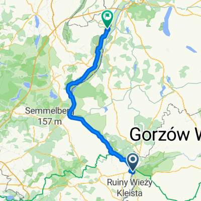
- Küstrin - Miedzyrzecz
- Distance
- 91.3 km
- Ascent
- 338 m
- Descent
- 304 m
- Location
- Manschnow, Brandenburg, Germany
- 8.4.2018 Anradeln nach Zechin
- Distance
- 33.3 km
- Ascent
- 4 m
- Descent
- 4 m
- Location
- Manschnow, Brandenburg, Germany
- 19.05.2013 Warthebruch
- Distance
- 84.3 km
- Ascent
- 106 m
- Descent
- 104 m
- Location
- Manschnow, Brandenburg, Germany
- Route: 5. Etappe "Oder-Neiße-Radweg": Küstrin - Bad Freienwalde
- Distance
- 59.1 km
- Ascent
- 22 m
- Descent
- 31 m
- Location
- Manschnow, Brandenburg, Germany
- Von Küstrin-Kietz nach Sulecin
- Distance
- 142.8 km
- Ascent
- 335 m
- Descent
- 336 m
- Location
- Manschnow, Brandenburg, Germany
- RUD06_03_Küstrin-Kietz - Fürstenberg-Oder(Eisenhuettenstadt)
- Distance
- 68.5 km
- Ascent
- 249 m
- Descent
- 215 m
- Location
- Manschnow, Brandenburg, Germany
Open it in the app