

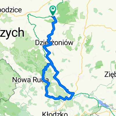
Przełęcz Jugowska-Srebrna Góra TERENEM.Czerwony pieszy szlak
A cycling route starting in Uciechów, Lower Silesian Voivodeship, Poland.
Overview
About this route
Wonderful views, technically difficult. A lot of climbing while pushing the bike. Beautifully marked red trail.
- -:--
- Duration
- 103.2 km
- Distance
- 1,138 m
- Ascent
- 1,136 m
- Descent
- ---
- Avg. speed
- ---
- Max. altitude
Route quality
Waytypes & surfaces along the route
Waytypes
Road
38.2 km
(37 %)
Track
26.8 km
(26 %)
Surfaces
Paved
48.5 km
(47 %)
Unpaved
14.4 km
(14 %)
Asphalt
48.5 km
(47 %)
Gravel
8.3 km
(8 %)
Continue with Bikemap
Use, edit, or download this cycling route
You would like to ride Przełęcz Jugowska-Srebrna Góra TERENEM.Czerwony pieszy szlak or customize it for your own trip? Here is what you can do with this Bikemap route:
Free features
- Save this route as favorite or in collections
- Copy & plan your own version of this route
- Split it into stages to create a multi-day tour
- Sync your route with Garmin or Wahoo
Premium features
Free trial for 3 days, or one-time payment. More about Bikemap Premium.
- Navigate this route on iOS & Android
- Export a GPX / KML file of this route
- Create your custom printout (try it for free)
- Download this route for offline navigation
Discover more Premium features.
Get Bikemap PremiumFrom our community
Other popular routes starting in Uciechów
 Kościelna 1, Dobrocin do Spacerowa, Piława Dolna
- Distance
- 5.2 km
- Ascent
- 7 m
- Descent
- 21 m
- Location
- Uciechów, Lower Silesian Voivodeship, Poland
 Byszów przez Uciechów. Powrót przez Stoszów,Jaźwinę
- Distance
- 44.6 km
- Ascent
- 207 m
- Descent
- 207 m
- Location
- Uciechów, Lower Silesian Voivodeship, Poland
 Niespodziewanie Rogów Sobócki,Pieszyce,Lasocin.
- Distance
- 98.7 km
- Ascent
- 588 m
- Descent
- 591 m
- Location
- Uciechów, Lower Silesian Voivodeship, Poland
 Bardo przez Przełęcz Woliborską
- Distance
- 121.7 km
- Ascent
- 799 m
- Descent
- 796 m
- Location
- Uciechów, Lower Silesian Voivodeship, Poland
 Trasa do Wiry 25B, Marcinowice
- Distance
- 30.6 km
- Ascent
- 562 m
- Descent
- 522 m
- Location
- Uciechów, Lower Silesian Voivodeship, Poland
 dzień trzeci
- Distance
- 115.7 km
- Ascent
- 822 m
- Descent
- 900 m
- Location
- Uciechów, Lower Silesian Voivodeship, Poland
 Wiry 53, Marcinowice do Wiry 25B, Marcinowice
- Distance
- 29.2 km
- Ascent
- 1,464 m
- Descent
- 1,464 m
- Location
- Uciechów, Lower Silesian Voivodeship, Poland
 Przełęcz Jugowska-Srebrna Góra TERENEM.Czerwony pieszy szlak
- Distance
- 103.2 km
- Ascent
- 1,138 m
- Descent
- 1,136 m
- Location
- Uciechów, Lower Silesian Voivodeship, Poland
Open it in the app