

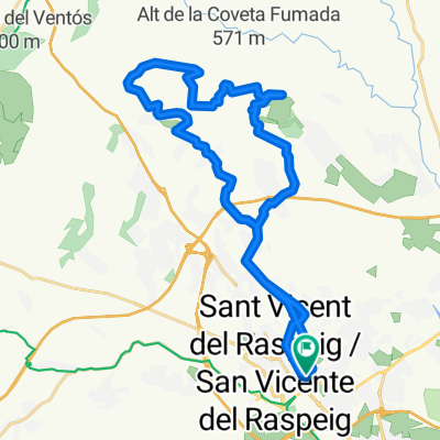
C.C.ALIBIKE: SAN VICENTE-MONNEGRE-TIBI-MAIGMO-AGOST-ASPE-HONDONES-ALBATERA-ELX-SANTA POLA-ALTET-TORRELLANO-ALICANTE
A cycling route starting in San Vicent del Raspeig, Valencia, Spain.
Overview
About this route
FULL ROUTE.
- -:--
- Duration
- 164 km
- Distance
- 1,247 m
- Ascent
- 1,315 m
- Descent
- ---
- Avg. speed
- ---
- Max. altitude

Route quality
Waytypes & surfaces along the route
Waytypes
Quiet road
42.6 km
(26 %)
Cycleway
31.2 km
(19 %)
Surfaces
Paved
36.1 km
(22 %)
Unpaved
1.6 km
(1 %)
Asphalt
36.1 km
(22 %)
Unpaved (undefined)
1.6 km
(1 %)
Undefined
126.3 km
(77 %)
Continue with Bikemap
Use, edit, or download this cycling route
You would like to ride C.C.ALIBIKE: SAN VICENTE-MONNEGRE-TIBI-MAIGMO-AGOST-ASPE-HONDONES-ALBATERA-ELX-SANTA POLA-ALTET-TORRELLANO-ALICANTE or customize it for your own trip? Here is what you can do with this Bikemap route:
Free features
- Save this route as favorite or in collections
- Copy & plan your own version of this route
- Split it into stages to create a multi-day tour
- Sync your route with Garmin or Wahoo
Premium features
Free trial for 3 days, or one-time payment. More about Bikemap Premium.
- Navigate this route on iOS & Android
- Export a GPX / KML file of this route
- Create your custom printout (try it for free)
- Download this route for offline navigation
Discover more Premium features.
Get Bikemap PremiumFrom our community
Other popular routes starting in San Vicent del Raspeig
 (1.880m) SAN VICENTE-AGOST-TIBI-XIXONA-TORREMANZANAS-RELLEU-AIGÜES-BUSOT-CAMPELLO-SAN VICENTE
- Distance
- 120.1 km
- Ascent
- 2,603 m
- Descent
- 2,544 m
- Location
- San Vicent del Raspeig, Valencia, Spain
 ALICANTE-TUDONS-ALICANTE
- Distance
- 124.2 km
- Ascent
- 1,741 m
- Descent
- 1,741 m
- Location
- San Vicent del Raspeig, Valencia, Spain
 moralet-xirau-cazadores-sabinar.gpx
- Distance
- 45.9 km
- Ascent
- 725 m
- Descent
- 721 m
- Location
- San Vicent del Raspeig, Valencia, Spain
 ruta sanve :)
- Distance
- 15.3 km
- Ascent
- 90 m
- Descent
- 88 m
- Location
- San Vicent del Raspeig, Valencia, Spain
 San Vicente-Campello-Aguas-Pantano Amadorio-Orxeta-Finestrat-Villajoyosa-Orxeta-Relleu-Aguas-Busot-Muchamiel-San Vicente
- Distance
- 111.5 km
- Ascent
- 1,123 m
- Descent
- 1,122 m
- Location
- San Vicent del Raspeig, Valencia, Spain
 Marcha MTB San Vicente 2010
- Distance
- 31.4 km
- Ascent
- 525 m
- Descent
- 525 m
- Location
- San Vicent del Raspeig, Valencia, Spain
 Ruta Marcha TREK Christmas Classic 2012 - San Vicente del Raspeig
- Distance
- 33.8 km
- Ascent
- 591 m
- Descent
- 589 m
- Location
- San Vicent del Raspeig, Valencia, Spain
 VIA VERDE MAIGMO DESDE SAN VICENTE DEL RASPEIG
- Distance
- 44.2 km
- Ascent
- 527 m
- Descent
- 527 m
- Location
- San Vicent del Raspeig, Valencia, Spain
Open it in the app