

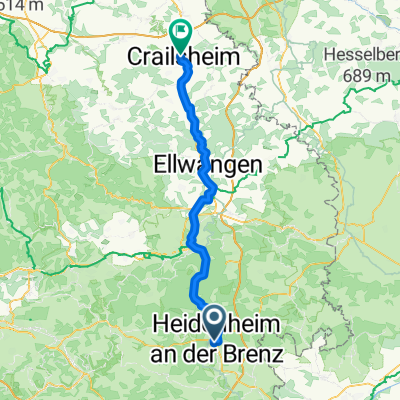
Härtsfeldtour Schnaitheim - Neresheim - Dischingen - Schnaitheim
A cycling route starting in Heidenheim, Baden-Wurttemberg, Germany.
Overview
About this route
Is well marked as 'Härtsfeldtour'
- -:--
- Duration
- 42.7 km
- Distance
- 567 m
- Ascent
- 541 m
- Descent
- ---
- Avg. speed
- 626 m
- Max. altitude

Route quality
Waytypes & surfaces along the route
Waytypes
Track
26.4 km
(62 %)
Quiet road
8.1 km
(19 %)
Surfaces
Paved
23.5 km
(55 %)
Unpaved
14.1 km
(33 %)
Asphalt
12.8 km
(30 %)
Paved (undefined)
9 km
(21 %)
Route highlights
Points of interest along the route

Photo after 16.1 km
Kloster Neresheim

Photo after 16.7 km
Schättere

Photo after 25.4 km
Taxis
Continue with Bikemap
Use, edit, or download this cycling route
You would like to ride Härtsfeldtour Schnaitheim - Neresheim - Dischingen - Schnaitheim or customize it for your own trip? Here is what you can do with this Bikemap route:
Free features
- Save this route as favorite or in collections
- Copy & plan your own version of this route
- Sync your route with Garmin or Wahoo
Premium features
Free trial for 3 days, or one-time payment. More about Bikemap Premium.
- Navigate this route on iOS & Android
- Export a GPX / KML file of this route
- Create your custom printout (try it for free)
- Download this route for offline navigation
Discover more Premium features.
Get Bikemap PremiumFrom our community
Other popular routes starting in Heidenheim
 Eselsburger Tal
- Distance
- 25.1 km
- Ascent
- 124 m
- Descent
- 124 m
- Location
- Heidenheim, Baden-Wurttemberg, Germany
 HDH - Gkuchen - Elchingen - Neresheim - Dischingen Nattheim - HDH
- Distance
- 58.3 km
- Ascent
- 429 m
- Descent
- 418 m
- Location
- Heidenheim, Baden-Wurttemberg, Germany
 Crailsheim nach Schloß Hellenstein
- Distance
- 72.5 km
- Ascent
- 534 m
- Descent
- 676 m
- Location
- Heidenheim, Baden-Wurttemberg, Germany
 Oberer Erbisberg 27, Heidenheim an der Brenz nach Oberer Erbisberg 23, Heidenheim an der Brenz
- Distance
- 14.3 km
- Ascent
- 93 m
- Descent
- 94 m
- Location
- Heidenheim, Baden-Wurttemberg, Germany
 Alb aktiv Heidenheim Ostalb
- Distance
- 46.4 km
- Ascent
- 537 m
- Descent
- 535 m
- Location
- Heidenheim, Baden-Wurttemberg, Germany
 Oberer Erbisberg 25, Heidenheim an der Brenz nach Oberer Erbisberg 25, Heidenheim an der Brenz
- Distance
- 14.6 km
- Ascent
- 237 m
- Descent
- 237 m
- Location
- Heidenheim, Baden-Wurttemberg, Germany
 Alb aktiv Heidenheim Ostalb
- Distance
- 46.4 km
- Ascent
- 536 m
- Descent
- 537 m
- Location
- Heidenheim, Baden-Wurttemberg, Germany
 Heidenheim/Schneitheim Zang Bartholomä Steinheim
- Distance
- 42.4 km
- Ascent
- 489 m
- Descent
- 493 m
- Location
- Heidenheim, Baden-Wurttemberg, Germany
Open it in the app