

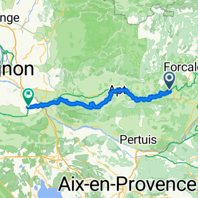
Trasa C – kaňonem Oppedette do Manosque
A cycling route starting in Reillanne, Provence-Alpes-Côte d'Azur Region, France.
Overview
About this route
We depart from the rotunda in the charming village Simiane-la-Rotonde and after a stop at the abbey, we head around one of the steepest canyons in Provence – the canyon d’Oppedette. We will visit the village of Viens perched on a rocky outcrop, and then the ancient priory church Prieuré de Carluc. From the village of Cereste, we will slowly make our way down along the foothills of the great Luberon towards Montfuron, where a well-preserved windmill stands; nearby is the chapel StElzeard. We will then descend to Manosque, the town already familiar for its natural cosmetics L'Occitanne. Here, in addition to the historical part of the town, we will also explore the city from above, from the tower of Mont d'Or on one of the hills near the center.
- -:--
- Duration
- 53.4 km
- Distance
- 886 m
- Ascent
- 1,226 m
- Descent
- ---
- Avg. speed
- ---
- Max. altitude

Route quality
Waytypes & surfaces along the route
Waytypes
Quiet road
22.4 km
(42 %)
Road
14.4 km
(27 %)
Surfaces
Paved
24 km
(45 %)
Unpaved
4.3 km
(8 %)
Asphalt
24 km
(45 %)
Gravel
3.2 km
(6 %)
Continue with Bikemap
Use, edit, or download this cycling route
You would like to ride Trasa C – kaňonem Oppedette do Manosque or customize it for your own trip? Here is what you can do with this Bikemap route:
Free features
- Save this route as favorite or in collections
- Copy & plan your own version of this route
- Sync your route with Garmin or Wahoo
Premium features
Free trial for 3 days, or one-time payment. More about Bikemap Premium.
- Navigate this route on iOS & Android
- Export a GPX / KML file of this route
- Create your custom printout (try it for free)
- Download this route for offline navigation
Discover more Premium features.
Get Bikemap PremiumFrom our community
Other popular routes starting in Reillanne
 Descente sur toulon
- Distance
- 170.7 km
- Ascent
- 1,173 m
- Descent
- 1,779 m
- Location
- Reillanne, Provence-Alpes-Côte d'Azur Region, France
 Dia 4 - Gite de Chaloux a Domain Saint Victor
- Distance
- 52.8 km
- Ascent
- 701 m
- Descent
- 997 m
- Location
- Reillanne, Provence-Alpes-Côte d'Azur Region, France
 Reillanne - Mollégès
- Distance
- 85.1 km
- Ascent
- 1,187 m
- Descent
- 1,685 m
- Location
- Reillanne, Provence-Alpes-Côte d'Azur Region, France
 Simiane-La-Rotonde - Rustrel - Oppedete - Manosque
- Distance
- 73.3 km
- Ascent
- 1,009 m
- Descent
- 1,312 m
- Location
- Reillanne, Provence-Alpes-Côte d'Azur Region, France
 24-16b Reillanne - Mirabeau
- Distance
- 74 km
- Ascent
- 699 m
- Descent
- 879 m
- Location
- Reillanne, Provence-Alpes-Côte d'Azur Region, France
 Reillanne - Volx Veloroute
- Distance
- 45.8 km
- Ascent
- 774 m
- Descent
- 803 m
- Location
- Reillanne, Provence-Alpes-Côte d'Azur Region, France
 Trasa C – kaňonem Oppedette do Manosque
- Distance
- 53.4 km
- Ascent
- 886 m
- Descent
- 1,226 m
- Location
- Reillanne, Provence-Alpes-Côte d'Azur Region, France
 20250701 Reillanne nach Pertuis
- Distance
- 41 km
- Ascent
- 459 m
- Descent
- 629 m
- Location
- Reillanne, Provence-Alpes-Côte d'Azur Region, France
Open it in the app