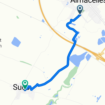
ruta2
- 34.8 km
- 259 m
- 259 m
- Almacelles, Catalonia, Spain
A cycling route starting in Almacelles, Catalonia, Spain.
Overview
We start in Almacelles from the Plaza de d'Il·lustració heading towards Rambla de Carles III. Once we reach the Aubacs area, we will turn left onto Carrer de Sucs, where at km 1 we will take the right path to cross the highway bridge and continue towards Suchs.
Around km 4, at the level of the Suchs cemetery, we will take a path on the right that climbs up to the Vilot Castle, where we will be able to observe some nice panoramic views of the area and visit the remains of the castle.
We will descend towards the village of Suchs to cross it in the West direction via Camí Bou heading towards Pla de la Font. Around km 8, we will take a turn on the right to approach the wooded area of Tossal de les Cabanes, where we will take a stretch through the forest before arriving at Pla de la Font (km 13).
Once we reach Pla de la Font, we will exit the village to the East towards the Mirador de Pla de la Font where we will take a route among the different ponds surrounding the mirador. We will continue the route heading towards the Castle of Gimenells by taking a piece of road that goes from Suchs to Gimenells (km 20). At this point, we have the option to visit the Castle of Gimenells which would extend the route by about 500 m.
The return route to Almacelles will take us up the Camarasa Valley to the highway bridge to head towards the zone of the Hermitage of Olivart (km 29) to travel the path until the stairs of the Betula Alba where we will enter Almacelles again.
End of the route (31 km)
created this 12 years ago
Continue with Bikemap
You would like to ride Proposta Caminada Almacelles or customize it for your own trip? Here is what you can do with this Bikemap route:
Free trial for 3 days, or one-time payment. More about Bikemap Premium.
Discover more Premium features.
Get Bikemap PremiumFrom our community
Open it in the app