

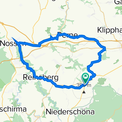
Naundorf - Meilerplatz Tharndt - Grillenburg Naundorf
A cycling route starting in Niederschöna, Saxony, Germany.
Overview
About this route
Rundweg auf Waldwegen im Tharandter Wald
- -:--
- Duration
- 29.9 km
- Distance
- 395 m
- Ascent
- 396 m
- Descent
- ---
- Avg. speed
- ---
- Max. altitude
Route quality
Waytypes & surfaces along the route
Waytypes
Track
21.8 km
(73 %)
Path
4.3 km
(15 %)
Surfaces
Paved
9 km
(30 %)
Unpaved
19.6 km
(66 %)
Gravel
12.5 km
(42 %)
Asphalt
8.6 km
(29 %)
Continue with Bikemap
Use, edit, or download this cycling route
You would like to ride Naundorf - Meilerplatz Tharndt - Grillenburg Naundorf or customize it for your own trip? Here is what you can do with this Bikemap route:
Free features
- Save this route as favorite or in collections
- Copy & plan your own version of this route
- Sync your route with Garmin or Wahoo
Premium features
Free trial for 3 days, or one-time payment. More about Bikemap Premium.
- Navigate this route on iOS & Android
- Export a GPX / KML file of this route
- Create your custom printout (try it for free)
- Download this route for offline navigation
Discover more Premium features.
Get Bikemap PremiumFrom our community
Other popular routes starting in Niederschöna
 obbad
obbad- Distance
- 30.4 km
- Ascent
- 213 m
- Descent
- 213 m
- Location
- Niederschöna, Saxony, Germany
 Falkenbeg Kuhstall na.Falkenberg Schloß
- Distance
- 99.6 km
- Ascent
- 400 m
- Descent
- 675 m
- Location
- Niederschöna, Saxony, Germany
 Nossen-Birkenhain-Runde
- Distance
- 41 km
- Ascent
- 301 m
- Descent
- 306 m
- Location
- Niederschöna, Saxony, Germany
 Halsbrücke-Rothenfurth
- Distance
- 18.6 km
- Ascent
- 227 m
- Descent
- 227 m
- Location
- Niederschöna, Saxony, Germany
 Rundtour zum Lipps Tullianfelsen (schöner Ausblick) und durch den Tharanter Wald zurück.
- Distance
- 21.3 km
- Ascent
- 239 m
- Descent
- 241 m
- Location
- Niederschöna, Saxony, Germany
 Naundorf -Talsperre Malter
- Distance
- 19.2 km
- Ascent
- 269 m
- Descent
- 291 m
- Location
- Niederschöna, Saxony, Germany
 Naundorf - Meilerplatz Tharndt - Grillenburg Naundorf
- Distance
- 29.9 km
- Ascent
- 395 m
- Descent
- 396 m
- Location
- Niederschöna, Saxony, Germany
 Erbgerichtsweg 13, Halsbrücke nach Erbgerichtsweg 13, Halsbrücke
- Distance
- 69.2 km
- Ascent
- 769 m
- Descent
- 762 m
- Location
- Niederschöna, Saxony, Germany
Open it in the app