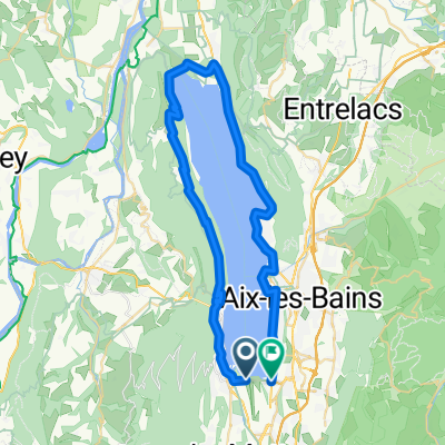
INES- Entre Deux Guiers via col de l'Epine
A cycling route starting in Le Bourget-du-Lac, Auvergne-Rh么ne-Alpes, France.
Overview
About this route
INES- Entre Deux Guiers via col de l'Epine
- -:--
- Duration
- 53.3 km
- Distance
- 1,155 m
- Ascent
- 1,001 m
- Descent
- ---
- Avg. speed
- ---
- Avg. speed
Route quality
Waytypes & surfaces along the route
Waytypes
Busy road
26.2 km
(49 %)
Road
22.8 km
(43 %)
Surfaces
Paved
33.8 km
(63 %)
Unpaved
0.6 km
(1 %)
Asphalt
31.9 km
(60 %)
Paved (undefined)
1.9 km
(3 %)
Continue with Bikemap
Use, edit, or download this cycling route
You would like to ride INES- Entre Deux Guiers via col de l'Epine or customize it for your own trip? Here is what you can do with this Bikemap route:
Free features
- Save this route as favorite or in collections
- Copy & plan your own version of this route
- Sync your route with Garmin or Wahoo
Premium features
Free trial for 3 days, or one-time payment. More about Bikemap Premium.
- Navigate this route on iOS & Android
- Export a GPX / KML file of this route
- Create your custom printout (try it for free)
- Download this route for offline navigation
Discover more Premium features.
Get Bikemap PremiumFrom our community
Other popular routes starting in Le Bourget-du-Lac
- tour_lac_Bourget_boulot
- Distance
- 50.9 km
- Ascent
- 590 m
- Descent
- 588 m
- Location
- Le Bourget-du-Lac, Auvergne-Rh么ne-Alpes, France
- Tour France_ Amb茅rieu-en-Bugey - Le Mont du Chat
- Distance
- 206.7 km
- Ascent
- 2,916 m
- Descent
- 4,117 m
- Location
- Le Bourget-du-Lac, Auvergne-Rh么ne-Alpes, France
- INES- Entre Deux Guiers via col du chat
- Distance
- 56.2 km
- Ascent
- 1,034 m
- Descent
- 881 m
- Location
- Le Bourget-du-Lac, Auvergne-Rh么ne-Alpes, France
- INES- Entre Deux Guiers via l'antenne du chat
- Distance
- 59 km
- Ascent
- 1,627 m
- Descent
- 1,473 m
- Location
- Le Bourget-du-Lac, Auvergne-Rh么ne-Alpes, France
- opdecahier_lacdubourget2004_04
- Distance
- 71.8 km
- Ascent
- 1,782 m
- Descent
- 1,173 m
- Location
- Le Bourget-du-Lac, Auvergne-Rh么ne-Alpes, France
- Stage3_2Draft_Ain17
- Distance
- 97.5 km
- Ascent
- 2,375 m
- Descent
- 2,172 m
- Location
- Le Bourget-du-Lac, Auvergne-Rh么ne-Alpes, France
- Mont du Chat and Col du Chat
- Distance
- 41.1 km
- Ascent
- 1,544 m
- Descent
- 1,544 m
- Location
- Le Bourget-du-Lac, Auvergne-Rh么ne-Alpes, France
- Bourget
- Distance
- 49.5 km
- Ascent
- 670 m
- Descent
- 672 m
- Location
- Le Bourget-du-Lac, Auvergne-Rh么ne-Alpes, France