

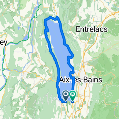
INES- Entre Deux Guiers via col du chat
A cycling route starting in Le Bourget-du-Lac, Auvergne-Rhône-Alpes, France.
Overview
About this route
INES - Entre Deux Guiers via col du chat
- -:--
- Duration
- 56.2 km
- Distance
- 1,034 m
- Ascent
- 881 m
- Descent
- ---
- Avg. speed
- ---
- Max. altitude
Route quality
Waytypes & surfaces along the route
Waytypes
Road
20.8 km
(37 %)
Quiet road
3.4 km
(6 %)
Surfaces
Paved
36.5 km
(65 %)
Unpaved
0.6 km
(1 %)
Asphalt
36.5 km
(65 %)
Gravel
0.6 km
(1 %)
Undefined
19.1 km
(34 %)
Continue with Bikemap
Use, edit, or download this cycling route
You would like to ride INES- Entre Deux Guiers via col du chat or customize it for your own trip? Here is what you can do with this Bikemap route:
Free features
- Save this route as favorite or in collections
- Copy & plan your own version of this route
- Sync your route with Garmin or Wahoo
Premium features
Free trial for 3 days, or one-time payment. More about Bikemap Premium.
- Navigate this route on iOS & Android
- Export a GPX / KML file of this route
- Create your custom printout (try it for free)
- Download this route for offline navigation
Discover more Premium features.
Get Bikemap PremiumFrom our community
Other popular routes starting in Le Bourget-du-Lac
 D 1201 A, Le Bourget-du-Lac à Montée de Pouli, Le Bourget-du-Lac
- Distance
- 4.7 km
- Ascent
- 96 m
- Descent
- 114 m
- Location
- Le Bourget-du-Lac, Auvergne-Rhône-Alpes, France
 Alpes 2013 5
- Distance
- 74 km
- Ascent
- 1,961 m
- Descent
- 1,307 m
- Location
- Le Bourget-du-Lac, Auvergne-Rhône-Alpes, France
 INES- Entre Deux Guiers via col du chat
- Distance
- 56.2 km
- Ascent
- 1,034 m
- Descent
- 881 m
- Location
- Le Bourget-du-Lac, Auvergne-Rhône-Alpes, France
 Mont du Chat via Col du Chat
- Distance
- 68.4 km
- Ascent
- 1,961 m
- Descent
- 1,960 m
- Location
- Le Bourget-du-Lac, Auvergne-Rhône-Alpes, France
 Tour France_ Ambérieu-en-Bugey - Le Mont du Chat
- Distance
- 206.7 km
- Ascent
- 2,916 m
- Descent
- 4,117 m
- Location
- Le Bourget-du-Lac, Auvergne-Rhône-Alpes, France
 INES- Entre Deux Guiers via l'antenne du chat
- Distance
- 59 km
- Ascent
- 1,627 m
- Descent
- 1,473 m
- Location
- Le Bourget-du-Lac, Auvergne-Rhône-Alpes, France
 Strecke H: Lac de Bourget nach Lac Leman
- Distance
- 119.4 km
- Ascent
- 1,396 m
- Descent
- 1,225 m
- Location
- Le Bourget-du-Lac, Auvergne-Rhône-Alpes, France
 Bourget
- Distance
- 49.5 km
- Ascent
- 670 m
- Descent
- 672 m
- Location
- Le Bourget-du-Lac, Auvergne-Rhône-Alpes, France
Open it in the app