

Karancs
A cycling route starting in Bátonyterenye, Nógrád megye, Hungary.
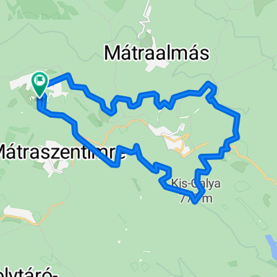
Overview
About this route
It was tough on the 5 kilometers uphill, rough terrain, wet rocks.
- -:--
- Duration
- 52.4 km
- Distance
- 413 m
- Ascent
- 417 m
- Descent
- ---
- Avg. speed
- ---
- Max. altitude

Continue with Bikemap
Use, edit, or download this cycling route
You would like to ride Karancs or customize it for your own trip? Here is what you can do with this Bikemap route:
Free features
- Save this route as favorite or in collections
- Copy & plan your own version of this route
- Sync your route with Garmin or Wahoo
Premium features
Free trial for 3 days, or one-time payment. More about Bikemap Premium.
- Navigate this route on iOS & Android
- Export a GPX / KML file of this route
- Create your custom printout (try it for free)
- Download this route for offline navigation
Discover more Premium features.
Get Bikemap PremiumFrom our community
Other popular routes starting in Bátonyterenye
 OKKT 2 - Heves-Borsodi-dombság
- Distance
- 81.5 km
- Ascent
- 505 m
- Descent
- 505 m
- Location
- Bátonyterenye, Nógrád megye, Hungary
 Sámsonháza
- Distance
- 37.9 km
- Ascent
- 207 m
- Descent
- 207 m
- Location
- Bátonyterenye, Nógrád megye, Hungary
 Mátraszentistván/ Sípark- Fekete tó (ZÖLD)
- Distance
- 8.1 km
- Ascent
- 146 m
- Descent
- 221 m
- Location
- Bátonyterenye, Nógrád megye, Hungary
 Kazár-Riolittufa
- Distance
- 22.2 km
- Ascent
- 194 m
- Descent
- 194 m
- Location
- Bátonyterenye, Nógrád megye, Hungary
 Kellemes 20 km
- Distance
- 20.2 km
- Ascent
- 310 m
- Descent
- 310 m
- Location
- Bátonyterenye, Nógrád megye, Hungary
 Mátra kiskör
- Distance
- 27.9 km
- Ascent
- 473 m
- Descent
- 467 m
- Location
- Bátonyterenye, Nógrád megye, Hungary
 Panoráma Körút a Felső Mátrában
- Distance
- 19.4 km
- Ascent
- 308 m
- Descent
- 306 m
- Location
- Bátonyterenye, Nógrád megye, Hungary
 Kisterenye-Szilvásvárad-Eger (Mátra@Bükk)
- Distance
- 92.1 km
- Ascent
- 468 m
- Descent
- 505 m
- Location
- Bátonyterenye, Nógrád megye, Hungary
Open it in the app