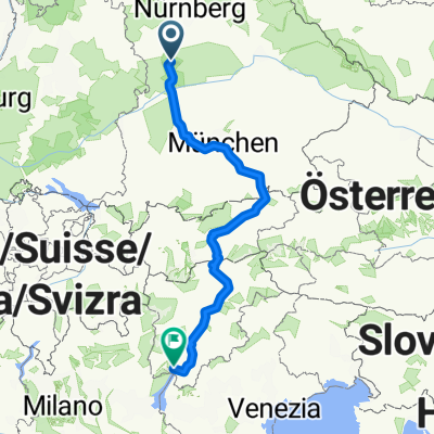
Hahnenkamm-Route
A cycling route starting in Wolferstadt, Bavaria, Germany.
Overview
About this route
Sehr schöne Strecke mit teilweise knackigen Anstiegen und rasanten Abfahrten. Ausschließlich geteerte Straßen.
- -:--
- Duration
- 59.5 km
- Distance
- 615 m
- Ascent
- 602 m
- Descent
- ---
- Avg. speed
- 634 m
- Avg. speed
Route quality
Waytypes & surfaces along the route
Waytypes
Busy road
25.8 km
(43 %)
Road
17 km
(29 %)
Surfaces
Paved
30.2 km
(51 %)
Unpaved
1.8 km
(3 %)
Asphalt
28.8 km
(48 %)
Gravel
1.8 km
(3 %)
Continue with Bikemap
Use, edit, or download this cycling route
You would like to ride Hahnenkamm-Route or customize it for your own trip? Here is what you can do with this Bikemap route:
Free features
- Save this route as favorite or in collections
- Copy & plan your own version of this route
- Sync your route with Garmin or Wahoo
Premium features
Free trial for 3 days, or one-time payment. More about Bikemap Premium.
- Navigate this route on iOS & Android
- Export a GPX / KML file of this route
- Create your custom printout (try it for free)
- Download this route for offline navigation
Discover more Premium features.
Get Bikemap PremiumFrom our community
Other popular routes starting in Wolferstadt
- Frankenstraße 54, Treuchtlingen nach Auf der Sünd 2, Treuchtlingen
- Distance
- 34.1 km
- Ascent
- 497 m
- Descent
- 513 m
- Location
- Wolferstadt, Bavaria, Germany
- Ottheinrichstraße 6, Wolferstadt nach Ottheinrichstraße 6, Wolferstadt
- Distance
- 23 km
- Ascent
- 389 m
- Descent
- 383 m
- Location
- Wolferstadt, Bavaria, Germany
- Auf der Sünd 4, Treuchtlingen nach Auf der Sünd 2, Treuchtlingen
- Distance
- 31.7 km
- Ascent
- 486 m
- Descent
- 502 m
- Location
- Wolferstadt, Bavaria, Germany
- Hahnenkamm-Route
- Distance
- 59.5 km
- Ascent
- 615 m
- Descent
- 602 m
- Location
- Wolferstadt, Bavaria, Germany
- Wieshof, Treuchtlingen
- Distance
- 32 km
- Ascent
- 368 m
- Descent
- 369 m
- Location
- Wolferstadt, Bavaria, Germany
- Uhlberg
- Distance
- 13.5 km
- Ascent
- 315 m
- Descent
- 298 m
- Location
- Wolferstadt, Bavaria, Germany
- Monheimer Alb
- Distance
- 94.2 km
- Ascent
- 1,000 m
- Descent
- 976 m
- Location
- Wolferstadt, Bavaria, Germany
- Auernheim-Uhlbergkapelle
- Distance
- 35.7 km
- Ascent
- 251 m
- Descent
- 407 m
- Location
- Wolferstadt, Bavaria, Germany
Open it in the app