

4 Täler-Tour Neckar-, Körsch-, Siebenmühlen-, Aich-, Neckartal
A cycling route starting in Nürtingen, Baden-Wurttemberg, Germany.
Overview
About this route
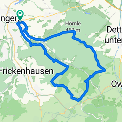
Start in Nürtingen at the train station. towards Oberboihingen, Wendlingen, Wernau nature reserve, Deizisau along the Neckar. After Deizisau, turn left into the Körschtal slightly uphill to Denkendorf, following the Körsch to Scharnhausen. a little detour to Hohenheim Castle. Leinfelden Echterdingen, Müllberg into the beautiful Siebenmühltal up to Burkhardsmühle, left towards Neuenhaus into the Aichtal, Grötzingen and back to Nürtingen.
- -:--
- Duration
- 60.4 km
- Distance
- 266 m
- Ascent
- 264 m
- Descent
- ---
- Avg. speed
- ---
- Max. altitude

Continue with Bikemap
Use, edit, or download this cycling route
You would like to ride 4 Täler-Tour Neckar-, Körsch-, Siebenmühlen-, Aich-, Neckartal or customize it for your own trip? Here is what you can do with this Bikemap route:
Free features
- Save this route as favorite or in collections
- Copy & plan your own version of this route
- Sync your route with Garmin or Wahoo
Premium features
Free trial for 3 days, or one-time payment. More about Bikemap Premium.
- Navigate this route on iOS & Android
- Export a GPX / KML file of this route
- Create your custom printout (try it for free)
- Download this route for offline navigation
Discover more Premium features.
Get Bikemap PremiumFrom our community
Other popular routes starting in Nürtingen
 Die Hügel von Nürtingen
- Distance
- 16.5 km
- Ascent
- 231 m
- Descent
- 231 m
- Location
- Nürtingen, Baden-Wurttemberg, Germany
 Engelshof
- Distance
- 43.2 km
- Ascent
- 782 m
- Descent
- 784 m
- Location
- Nürtingen, Baden-Wurttemberg, Germany
 Alb-Panorama
- Distance
- 60.4 km
- Ascent
- 419 m
- Descent
- 416 m
- Location
- Nürtingen, Baden-Wurttemberg, Germany
 2010-Tag9: Nürtlingen-Geradstetten (Zelt)
- Distance
- 56.5 km
- Ascent
- 169 m
- Descent
- 201 m
- Location
- Nürtingen, Baden-Wurttemberg, Germany
 nürtingen-Weiler Hütte
- Distance
- 40.7 km
- Ascent
- 303 m
- Descent
- 259 m
- Location
- Nürtingen, Baden-Wurttemberg, Germany
 NT Rundtour an NT beidseitig Tiefenbachtal
- Distance
- 22.6 km
- Ascent
- 410 m
- Descent
- 410 m
- Location
- Nürtingen, Baden-Wurttemberg, Germany
 Runde von Nürtingen, Naturpark Schönbuch, Tübingen
- Distance
- 61.9 km
- Ascent
- 468 m
- Descent
- 468 m
- Location
- Nürtingen, Baden-Wurttemberg, Germany
 Nürtingen-Lämmerbuckel und zurück
- Distance
- 86.8 km
- Ascent
- 1,257 m
- Descent
- 1,183 m
- Location
- Nürtingen, Baden-Wurttemberg, Germany
Open it in the app