

Requena, Villar Tejas. Mataparda
A cycling route starting in Requena, Valencia, Spain.
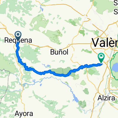
Overview
About this route
Ruta de nivel medio, con vistas preciosas desde El Remedio. El pantano de Benageber tiene un tunel peligroso. No esta iluminado.
- -:--
- Duration
- 119.6 km
- Distance
- 1,625 m
- Ascent
- 1,631 m
- Descent
- ---
- Avg. speed
- ---
- Max. altitude
Route quality
Waytypes & surfaces along the route
Waytypes
Busy road
102 km
(85 %)
Road
9.8 km
(8 %)
Surfaces
Paved
1 km
(<1 %)
Unpaved
0.2 km
(<1 %)
Asphalt
1 km
(<1 %)
Gravel
0.2 km
(<1 %)
Undefined
118.5 km
(99 %)
Continue with Bikemap
Use, edit, or download this cycling route
You would like to ride Requena, Villar Tejas. Mataparda or customize it for your own trip? Here is what you can do with this Bikemap route:
Free features
- Save this route as favorite or in collections
- Copy & plan your own version of this route
- Split it into stages to create a multi-day tour
- Sync your route with Garmin or Wahoo
Premium features
Free trial for 3 days, or one-time payment. More about Bikemap Premium.
- Navigate this route on iOS & Android
- Export a GPX / KML file of this route
- Create your custom printout (try it for free)
- Download this route for offline navigation
Discover more Premium features.
Get Bikemap PremiumFrom our community
Other popular routes starting in Requena
 Ruta 35 : La Portera - Yatova - Dos Aguas
- Distance
- 55.9 km
- Ascent
- 976 m
- Descent
- 1,253 m
- Location
- Requena, Valencia, Spain
 La Portera-OF Casa del Doctor-OF Sierra Martés
- Distance
- 66.1 km
- Ascent
- 893 m
- Descent
- 892 m
- Location
- Requena, Valencia, Spain
 Ruta 36 : Requena - Utiel
- Distance
- 39.2 km
- Ascent
- 755 m
- Descent
- 733 m
- Location
- Requena, Valencia, Spain
 Requena Valencia por Millares
- Distance
- 93.4 km
- Ascent
- 771 m
- Descent
- 1,374 m
- Location
- Requena, Valencia, Spain
 Requena, Villar Tejas. Mataparda
- Distance
- 119.6 km
- Ascent
- 1,625 m
- Descent
- 1,631 m
- Location
- Requena, Valencia, Spain
 Ruta 17: Requena - Chera - Chelva
- Distance
- 62.2 km
- Ascent
- 863 m
- Descent
- 1,111 m
- Location
- Requena, Valencia, Spain
 Ruta 12: Requena - Pto Negrete -Benageber embalse
- Distance
- 55.7 km
- Ascent
- 798 m
- Descent
- 1,052 m
- Location
- Requena, Valencia, Spain
 requena - bugarra mayo/mai/may 2016
- Distance
- 74.6 km
- Ascent
- 634 m
- Descent
- 1,157 m
- Location
- Requena, Valencia, Spain
Open it in the app