

C2C -7童軍鐵騎 長征七號 路線規劃圖
A cycling route starting in Chang-hua, Taiwan, Taiwan.
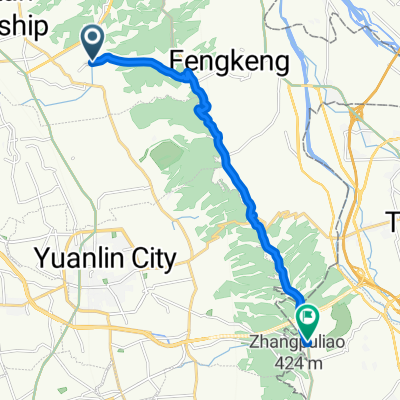
Overview
About this route
千呼喚換始出來
看看這次勇敢長征的路線吧!!- -:--
- Duration
- 135.4 km
- Distance
- 692 m
- Ascent
- 693 m
- Descent
- ---
- Avg. speed
- ---
- Max. altitude

Route highlights
Points of interest along the route
Point of interest after 15.8 km
寶藏寺
Point of interest after 25.2 km
國立台灣工藝文化園區
Point of interest after 30.9 km
土城國小後土地公廟
Point of interest after 31.4 km
準備衝刺
Point of interest after 41 km
廟
Point of interest after 42.6 km
國姓驛站
Point of interest after 51.3 km
壹咖啡 準備攀登
Point of interest after 56.2 km
北梅國中
Point of interest after 63.7 km
合成派出所
Point of interest after 75.2 km
埔里高工 國家地理中心碑
Point of interest after 131.8 km
結業式
Continue with Bikemap
Use, edit, or download this cycling route
You would like to ride C2C -7童軍鐵騎 長征七號 路線規劃圖 or customize it for your own trip? Here is what you can do with this Bikemap route:
Free features
- Save this route as favorite or in collections
- Copy & plan your own version of this route
- Split it into stages to create a multi-day tour
- Sync your route with Garmin or Wahoo
Premium features
Free trial for 3 days, or one-time payment. More about Bikemap Premium.
- Navigate this route on iOS & Android
- Export a GPX / KML file of this route
- Create your custom printout (try it for free)
- Download this route for offline navigation
Discover more Premium features.
Get Bikemap PremiumFrom our community
Other popular routes starting in Chang-hua
 2009.4.12 快官~八卦山~賞鷹平臺~楊桃崎~禾家~四面佛O型
- Distance
- 30.2 km
- Ascent
- 572 m
- Descent
- 568 m
- Location
- Chang-hua, Taiwan, Taiwan
 C2C3 DAY1彰化-潭雅神-后豐-大甲
- Distance
- 72.4 km
- Ascent
- 393 m
- Descent
- 354 m
- Location
- Chang-hua, Taiwan, Taiwan
 花壇三芬橋到鳳山寺
- Distance
- 14.2 km
- Ascent
- 429 m
- Descent
- 75 m
- Location
- Chang-hua, Taiwan, Taiwan
 八卦山休閒路線
- Distance
- 12.9 km
- Ascent
- 178 m
- Descent
- 103 m
- Location
- Chang-hua, Taiwan, Taiwan
 虎山岩-日月山景
- Distance
- 19.7 km
- Ascent
- 237 m
- Descent
- 232 m
- Location
- Chang-hua, Taiwan, Taiwan
 穩定的乘坐 烏日區
- Distance
- 38 km
- Ascent
- 38 m
- Descent
- 69 m
- Location
- Chang-hua, Taiwan, Taiwan
 中彰轉-139 路段 車少空氣好
- Distance
- 35 km
- Ascent
- 452 m
- Descent
- 425 m
- Location
- Chang-hua, Taiwan, Taiwan
 東外環-三分橋-員林大碗公
- Distance
- 42.9 km
- Ascent
- 368 m
- Descent
- 371 m
- Location
- Chang-hua, Taiwan, Taiwan
Open it in the app