
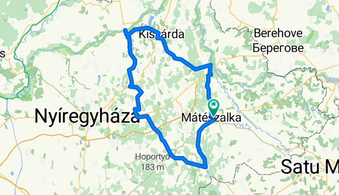
Szabolcs-szatmár-bereg megyei kör
A cycling route starting in Mátészalka, Szabolcs-Szatmár-Bereg, Hungary.
Overview
About this route
0
The loop around the lake was surrounded by a short stretch of dirt road, otherwise it was all tarmacked.
- -:--
- Duration
- 165.6 km
- Distance
- 100 m
- Ascent
- 99 m
- Descent
- ---
- Avg. speed
- ---
- Max. altitude
pradaz
created this 13 years ago
Route quality
Waytypes & surfaces along the route
Waytypes
Quiet road
33.1 km
20 %
Cycleway
11.6 km
7 %
Surfaces
Paved
79.5 km
(48 %)
Unpaved
6.6 km
(4 %)
Asphalt
77.8 km
47 %
Loose gravel
5 km
3 %
Continue with Bikemap
Use, edit, or download this cycling route
You would like to ride Szabolcs-szatmár-bereg megyei kör or customize it for your own trip? Here is what you can do with this Bikemap route:
Free features
- Save this route as favorite or in collections
- Copy & plan your own version of this route
- Split it into stages to create a multi-day tour
- Sync your route with Garmin or Wahoo
Premium features
Free trial for 3 days, or one-time payment. More about Bikemap Premium.
- Navigate this route on iOS & Android
- Export a GPX / KML file of this route
- Create your custom printout (try it for free)
- Download this route for offline navigation
Discover more Premium features.
Get Bikemap PremiumFrom our community
Other popular routes starting in Mátészalka
- Kálvin tér, Mátészalka - Kölcsey tér, Mátészalka0
- 41.9 km
- 42 m
- 34 m
- Mátészalka, Szabolcs-Szatmár-Bereg, Hungary


Open it in the app