

PA Grand Canyon Rail to Trail
A cycling route starting in Wellsboro, Pennsylvania, United States.
Overview
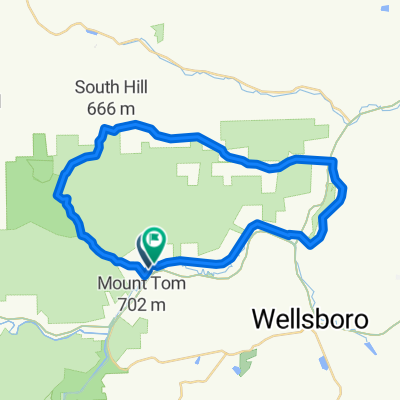
About this route
This is a PA Rail to Trail.
Parking, Nature Center and Rest Facilities at trail head. Trail is very smooth with a 1 to 2% down grade heading south. Actual trail far extends this 16k / 10mi piece.
Opportunity to see wildlife while in the canyon. Great for all skill levels!! Great for picnic.
- -:--
- Duration
- 16.1 km
- Distance
- 80 m
- Ascent
- 126 m
- Descent
- ---
- Avg. speed
- 385 m
- Max. altitude
Route quality
Waytypes & surfaces along the route
Waytypes
Cycleway
16.1 km
(100 %)
Surfaces
Unpaved
16.1 km
(100 %)
Loose gravel
16.1 km
(100 %)
Continue with Bikemap
Use, edit, or download this cycling route
You would like to ride PA Grand Canyon Rail to Trail or customize it for your own trip? Here is what you can do with this Bikemap route:
Free features
- Save this route as favorite or in collections
- Copy & plan your own version of this route
- Sync your route with Garmin or Wahoo
Premium features
Free trial for 3 days, or one-time payment. More about Bikemap Premium.
- Navigate this route on iOS & Android
- Export a GPX / KML file of this route
- Create your custom printout (try it for free)
- Download this route for offline navigation
Discover more Premium features.
Get Bikemap PremiumFrom our community
Other popular routes starting in Wellsboro
 Marsh Creek Road to Marsh Creek Road via Muck
- Distance
- 40.8 km
- Ascent
- 565 m
- Descent
- 563 m
- Location
- Wellsboro, Pennsylvania, United States
 The Ladle - Day 2 - Ascension Awaits
- Distance
- 95.4 km
- Ascent
- 1,164 m
- Descent
- 1,301 m
- Location
- Wellsboro, Pennsylvania, United States
 pine creek rail trail, pa.
- Distance
- 87.4 km
- Ascent
- 954 m
- Descent
- 1,137 m
- Location
- Wellsboro, Pennsylvania, United States
 Laurel Flyer Road Race
- Distance
- 38.2 km
- Ascent
- 493 m
- Descent
- 478 m
- Location
- Wellsboro, Pennsylvania, United States
 PA Grand Canyon Rail to Trail
- Distance
- 16.1 km
- Ascent
- 80 m
- Descent
- 126 m
- Location
- Wellsboro, Pennsylvania, United States
 4758 US-6, Wellsboro to Colton Rd, Wellsboro
- Distance
- 31 km
- Ascent
- 794 m
- Descent
- 604 m
- Location
- Wellsboro, Pennsylvania, United States
 Grand Canyon of Pennsylvania wrong direction
- Distance
- 14.1 km
- Ascent
- 77 m
- Descent
- 77 m
- Location
- Wellsboro, Pennsylvania, United States
 Wellsboro to Lake Ontario
- Distance
- 369.7 km
- Ascent
- 985 m
- Descent
- 1,299 m
- Location
- Wellsboro, Pennsylvania, United States
Open it in the app