

Kanal und Moor, ebenerdig und ruhig
A cycling route starting in Osterrönfeld, Schleswig-Holstein, Germany.
Overview
About this route
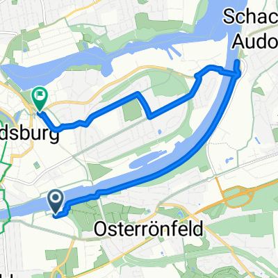
The route leads from the high bridge (parking possibility) along the canal and the railway to the Nobiskrug ferry. On the other side, it goes along back paths to Osterrönfeld and to the edge of the town.
Behind the fields, there is a large community garden and an old, unknown building.
Through Westerrönfeld, one goes via side streets to the pedestrian tunnel.
Here, near the end of the route, there is the option to treat oneself either before the tunnel or on the other side, at the district harbor, with an ice cream. Afterwards, the route leads back to the starting point, where there is still the 3rd option to cross the canal by flying. All 3 crossings are, by the way, free of charge!
(cloned from route 1294377)
- -:--
- Duration
- 27 km
- Distance
- 71 m
- Ascent
- 69 m
- Descent
- ---
- Avg. speed
- ---
- Max. altitude

Continue with Bikemap
Use, edit, or download this cycling route
You would like to ride Kanal und Moor, ebenerdig und ruhig or customize it for your own trip? Here is what you can do with this Bikemap route:
Free features
- Save this route as favorite or in collections
- Copy & plan your own version of this route
- Sync your route with Garmin or Wahoo
Premium features
Free trial for 3 days, or one-time payment. More about Bikemap Premium.
- Navigate this route on iOS & Android
- Export a GPX / KML file of this route
- Create your custom printout (try it for free)
- Download this route for offline navigation
Discover more Premium features.
Get Bikemap PremiumFrom our community
Other popular routes starting in Osterrönfeld
 Tag 5 Rendsburg -Schönberger Strand
- Distance
- 97.3 km
- Ascent
- 195 m
- Descent
- 204 m
- Location
- Osterrönfeld, Schleswig-Holstein, Germany
 Von Osterrönfeld bis Rendsburg
- Distance
- 7.9 km
- Ascent
- 39 m
- Descent
- 35 m
- Location
- Osterrönfeld, Schleswig-Holstein, Germany
 Am Kreishafen 36, Rendsburg nach Pastor-Schröder-Straße 21A, Rendsburg
- Distance
- 7.8 km
- Ascent
- 9 m
- Descent
- 12 m
- Location
- Osterrönfeld, Schleswig-Holstein, Germany
 RR-Naturpark Westensee
- Distance
- 79.8 km
- Ascent
- 154 m
- Descent
- 154 m
- Location
- Osterrönfeld, Schleswig-Holstein, Germany
 Kieler Straße 19, Osterrönfeld nach Kamp 6, Rickert
- Distance
- 7.1 km
- Ascent
- 32 m
- Descent
- 31 m
- Location
- Osterrönfeld, Schleswig-Holstein, Germany
 NOK-Rdb-Landwehr_32
- Distance
- 31.9 km
- Ascent
- 106 m
- Descent
- 107 m
- Location
- Osterrönfeld, Schleswig-Holstein, Germany
 Kanal und Moor, ebenerdig und ruhig
- Distance
- 16 km
- Ascent
- 71 m
- Descent
- 69 m
- Location
- Osterrönfeld, Schleswig-Holstein, Germany
 NOK 4 - Rendsburg-Schwebefähre bis Breiholz
- Distance
- 26.2 km
- Ascent
- 29 m
- Descent
- 29 m
- Location
- Osterrönfeld, Schleswig-Holstein, Germany
Open it in the app