

san marco
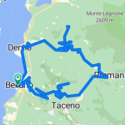
A cycling route starting in Bellano, Lombardy, Italy.
Overview
About this route
beautiful landscape
- -:--
- Duration
- 154.1 km
- Distance
- 2,755 m
- Ascent
- 2,752 m
- Descent
- ---
- Avg. speed
- ---
- Max. altitude
Continue with Bikemap
Use, edit, or download this cycling route
You would like to ride san marco or customize it for your own trip? Here is what you can do with this Bikemap route:
Free features
- Save this route as favorite or in collections
- Copy & plan your own version of this route
- Split it into stages to create a multi-day tour
- Sync your route with Garmin or Wahoo
Premium features
Free trial for 3 days, or one-time payment. More about Bikemap Premium.
- Navigate this route on iOS & Android
- Export a GPX / KML file of this route
- Create your custom printout (try it for free)
- Download this route for offline navigation
Discover more Premium features.
Get Bikemap PremiumFrom our community
Other popular routes starting in Bellano
 Bellano
- Distance
- 72 km
- Ascent
- 2,390 m
- Descent
- 2,390 m
- Location
- Bellano, Lombardy, Italy
 Circuit above Bellano
- Distance
- 64 km
- Ascent
- 4,435 m
- Descent
- 4,435 m
- Location
- Bellano, Lombardy, Italy
 griante - passo san marco - bellano - griante
- Distance
- 115.4 km
- Ascent
- 1,890 m
- Descent
- 1,890 m
- Location
- Bellano, Lombardy, Italy
 Bellano - Narro - Monte Legnoncino - Bellano
- Distance
- 73.5 km
- Ascent
- 2,353 m
- Descent
- 2,343 m
- Location
- Bellano, Lombardy, Italy
 Noceno - Dervio
- Distance
- 5 km
- Ascent
- 39 m
- Descent
- 673 m
- Location
- Bellano, Lombardy, Italy
 Monte Sommafiume - Premana - Taceno
- Distance
- 64.2 km
- Ascent
- 1,809 m
- Descent
- 1,809 m
- Location
- Bellano, Lombardy, Italy
 bellano to menaggio
- Distance
- 50.5 km
- Ascent
- 637 m
- Descent
- 641 m
- Location
- Bellano, Lombardy, Italy
 san marco
- Distance
- 154.1 km
- Ascent
- 2,755 m
- Descent
- 2,752 m
- Location
- Bellano, Lombardy, Italy
Open it in the app