

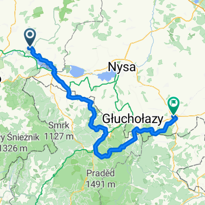
KZ - Złoty Stok - Javornik - Lądek Z. - Ołdrzychowice - Jaszkowa Górna - Podzamek - Kłodzko - Wojbórz - Bardo - KZ
A cycling route starting in Kamieniec Ząbkowicki, Lower Silesian Voivodeship, Poland.
Overview
About this route
KZ - Złoty Stok - Javornik - Lądek Z. - Ołdrzychowice - Jaszkowa Górna - Podzamek - Kłodzko - Wojbórz - Bardo - KZ
- -:--
- Duration
- 99.7 km
- Distance
- 825 m
- Ascent
- 822 m
- Descent
- ---
- Avg. speed
- ---
- Max. altitude

Route quality
Waytypes & surfaces along the route
Waytypes
Road
37.9 km
(38 %)
Quiet road
12 km
(12 %)
Surfaces
Paved
76.7 km
(77 %)
Asphalt
75.7 km
(76 %)
Paved (undefined)
1 km
(1 %)
Undefined
22.9 km
(23 %)
Continue with Bikemap
Use, edit, or download this cycling route
You would like to ride KZ - Złoty Stok - Javornik - Lądek Z. - Ołdrzychowice - Jaszkowa Górna - Podzamek - Kłodzko - Wojbórz - Bardo - KZ or customize it for your own trip? Here is what you can do with this Bikemap route:
Free features
- Save this route as favorite or in collections
- Copy & plan your own version of this route
- Split it into stages to create a multi-day tour
- Sync your route with Garmin or Wahoo
Premium features
Free trial for 3 days, or one-time payment. More about Bikemap Premium.
- Navigate this route on iOS & Android
- Export a GPX / KML file of this route
- Create your custom printout (try it for free)
- Download this route for offline navigation
Discover more Premium features.
Get Bikemap PremiumFrom our community
Other popular routes starting in Kamieniec Ząbkowicki
 Góry Bardzkie
- Distance
- 56.4 km
- Ascent
- 737 m
- Descent
- 737 m
- Location
- Kamieniec Ząbkowicki, Lower Silesian Voivodeship, Poland
 Wycieczka przez Jesioniki i Opolszczyznę
- Distance
- 103.6 km
- Ascent
- 847 m
- Descent
- 845 m
- Location
- Kamieniec Ząbkowicki, Lower Silesian Voivodeship, Poland
 KZ - Złoty Stok - Javornik - Lądek Z. - Ołdrzychowice - Jaszkowa Górna - Podzamek - Kłodzko - Wojbórz - Bardo - KZ
- Distance
- 99.7 km
- Ascent
- 825 m
- Descent
- 822 m
- Location
- Kamieniec Ząbkowicki, Lower Silesian Voivodeship, Poland
 Zloty stok
- Distance
- 150 km
- Ascent
- 1,879 m
- Descent
- 1,880 m
- Location
- Kamieniec Ząbkowicki, Lower Silesian Voivodeship, Poland
 KZ - Niedźwiednik - Stolec (kier. Sieroszów) - Jaworek - Stolec (stadion) - Strąkowa - Braszowice - Strąkowa - KZ
- Distance
- 42.2 km
- Ascent
- 254 m
- Descent
- 252 m
- Location
- Kamieniec Ząbkowicki, Lower Silesian Voivodeship, Poland
 "Srebrna Góra" Kamieniec Ząbkowicki - Strzelin
- Distance
- 87.9 km
- Ascent
- 669 m
- Descent
- 744 m
- Location
- Kamieniec Ząbkowicki, Lower Silesian Voivodeship, Poland
 opcja nr 2
- Distance
- 318.2 km
- Ascent
- 1,602 m
- Descent
- 1,612 m
- Location
- Kamieniec Ząbkowicki, Lower Silesian Voivodeship, Poland
 mLHT #1: KZ - Laski - Kłodzko - Czerwieńczyce - Srebrna Góra - Ząbkowice Śl. - KZ
- Distance
- 69.6 km
- Ascent
- 645 m
- Descent
- 645 m
- Location
- Kamieniec Ząbkowicki, Lower Silesian Voivodeship, Poland
Open it in the app