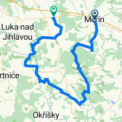
Měřínská 50 - 013- trasa 65 km
A cycling route starting in Měřín, Kraj Vysočina, Czechia.
Overview
About this route
cold 12 degrees, together with Jirka and Janča
- -:--
- Duration
- 66.2 km
- Distance
- 566 m
- Ascent
- 566 m
- Descent
- ---
- Avg. speed
- ---
- Max. altitude
Continue with Bikemap
Use, edit, or download this cycling route
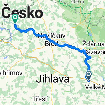
You would like to ride Měřínská 50 - 013- trasa 65 km or customize it for your own trip? Here is what you can do with this Bikemap route:
Free features
- Save this route as favorite or in collections
- Copy & plan your own version of this route
- Sync your route with Garmin or Wahoo
Premium features
Free trial for 3 days, or one-time payment. More about Bikemap Premium.
- Navigate this route on iOS & Android
- Export a GPX / KML file of this route
- Create your custom printout (try it for free)
- Download this route for offline navigation
Discover more Premium features.
Get Bikemap PremiumFrom our community
Other popular routes starting in Měřín
- uhrinov-olomouc
- Distance
- 143.6 km
- Ascent
- 1,197 m
- Descent
- 1,491 m
- Location
- Měřín, Kraj Vysočina, Czechia
- trasa2 CLONED FROM ROUTE 420128
- Distance
- 78.7 km
- Ascent
- 665 m
- Descent
- 665 m
- Location
- Měřín, Kraj Vysočina, Czechia
- Okruh Balinským údolím přes Kamennou
- Distance
- 54 km
- Ascent
- 491 m
- Descent
- 491 m
- Location
- Měřín, Kraj Vysočina, Czechia
- Netín do Silnice Bez Názvu
- Distance
- 6.3 km
- Ascent
- 176 m
- Descent
- 26 m
- Location
- Měřín, Kraj Vysočina, Czechia
- Netín do Pavlov
- Distance
- 4.6 km
- Ascent
- 110 m
- Descent
- 54 m
- Location
- Měřín, Kraj Vysočina, Czechia
- Měřín do Na Potoce
- Distance
- 83.9 km
- Ascent
- 1,115 m
- Descent
- 1,301 m
- Location
- Měřín, Kraj Vysočina, Czechia
- 20151010_121436
- Distance
- 57.4 km
- Ascent
- 549 m
- Descent
- 551 m
- Location
- Měřín, Kraj Vysočina, Czechia
- Z Měřína
- Distance
- 82.9 km
- Ascent
- 834 m
- Descent
- 834 m
- Location
- Měřín, Kraj Vysočina, Czechia
Open it in the app