

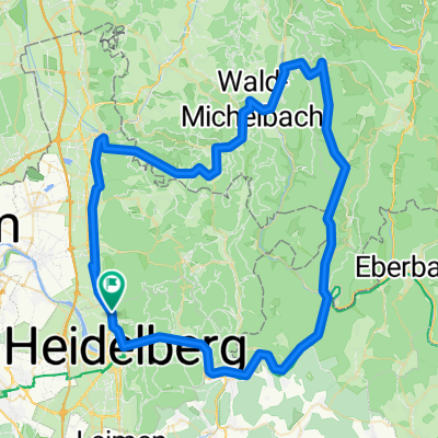
Dossenheim-Heidelberg
A cycling route starting in Dossenheim, Baden-Wurttemberg, Germany.
Overview
About this route
- -:--
- Duration
- 8.3 km
- Distance
- 8 m
- Ascent
- 7 m
- Descent
- ---
- Avg. speed
- 114 m
- Max. altitude
Route quality
Waytypes & surfaces along the route
Waytypes
Quiet road
1.9 km
(23 %)
Path
1.7 km
(20 %)
Surfaces
Paved
6.5 km
(78 %)
Unpaved
0.7 km
(8 %)
Asphalt
6.3 km
(76 %)
Ground
0.6 km
(7 %)
Route highlights
Points of interest along the route
Point of interest after 3.7 km
Continue with Bikemap
Use, edit, or download this cycling route
You would like to ride Dossenheim-Heidelberg or customize it for your own trip? Here is what you can do with this Bikemap route:
Free features
- Save this route as favorite or in collections
- Copy & plan your own version of this route
- Sync your route with Garmin or Wahoo
Premium features
Free trial for 3 days, or one-time payment. More about Bikemap Premium.
- Navigate this route on iOS & Android
- Export a GPX / KML file of this route
- Create your custom printout (try it for free)
- Download this route for offline navigation
Discover more Premium features.
Get Bikemap PremiumFrom our community
Other popular routes starting in Dossenheim
 Triple-X
- Distance
- 56.7 km
- Ascent
- 1,846 m
- Descent
- 1,847 m
- Location
- Dossenheim, Baden-Wurttemberg, Germany
 TourSA130609
- Distance
- 85.8 km
- Ascent
- 1,146 m
- Descent
- 1,128 m
- Location
- Dossenheim, Baden-Wurttemberg, Germany
 Abendrunde / Saisonbeginn
- Distance
- 35.3 km
- Ascent
- 73 m
- Descent
- 73 m
- Location
- Dossenheim, Baden-Wurttemberg, Germany
 Odenwald Runde
- Distance
- 60.2 km
- Ascent
- 1,119 m
- Descent
- 1,119 m
- Location
- Dossenheim, Baden-Wurttemberg, Germany
 DO_Rimbachtal_WS
- Distance
- 18.8 km
- Ascent
- 664 m
- Descent
- 247 m
- Location
- Dossenheim, Baden-Wurttemberg, Germany
 Weißer Stein Bergzeitfahren
- Distance
- 6.8 km
- Ascent
- 530 m
- Descent
- 86 m
- Location
- Dossenheim, Baden-Wurttemberg, Germany
 von Dossenheim auf Schleichwegen in den Odenwald
- Distance
- 58.5 km
- Ascent
- 1,188 m
- Descent
- 1,188 m
- Location
- Dossenheim, Baden-Wurttemberg, Germany
 SchriesheimerTal_Wilhemsfeld_Apfelkopf
- Distance
- 28.3 km
- Ascent
- 746 m
- Descent
- 728 m
- Location
- Dossenheim, Baden-Wurttemberg, Germany
Open it in the app