Süßen - Lützelalb - Messeberg - Süßen
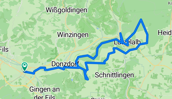
A cycling route starting in Süßen, Baden-Wurttemberg, Germany.
Overview
About this route
from Süßen it goes along the high trail to Wißenstein, then up to Lützelalb, then near Treffelhausen to Messelberg and down to Donzdorf
- -:--
- Duration
- 40.7 km
- Distance
- 906 m
- Ascent
- 816 m
- Descent
- ---
- Avg. speed
- 756 m
- Max. altitude
Route quality
Waytypes & surfaces along the route
Waytypes
Track
23.6 km
(58 %)
Quiet road
9.4 km
(23 %)
Surfaces
Paved
15.1 km
(37 %)
Unpaved
17.5 km
(43 %)
Asphalt
11.4 km
(28 %)
Unpaved (undefined)
8.1 km
(20 %)
Route highlights
Points of interest along the route
Point of interest after 0 km
Start ud Ziel beim Rathaus in Süßen
Point of interest after 17 km
Lützelalb
Continue with Bikemap
Use, edit, or download this cycling route
You would like to ride Süßen - Lützelalb - Messeberg - Süßen or customize it for your own trip? Here is what you can do with this Bikemap route:
Free features
- Save this route as favorite or in collections
- Copy & plan your own version of this route
- Sync your route with Garmin or Wahoo
Premium features
Free trial for 3 days, or one-time payment. More about Bikemap Premium.
- Navigate this route on iOS & Android
- Export a GPX / KML file of this route
- Create your custom printout (try it for free)
- Download this route for offline navigation
Discover more Premium features.
Get Bikemap PremiumFrom our community
Other popular routes starting in Süßen
- Bossler-Reußenstein-Filsursprung
- Distance
- 60.3 km
- Ascent
- 1,010 m
- Descent
- 1,008 m
- Location
- Süßen, Baden-Wurttemberg, Germany
- ASF 2007
- Distance
- 94.9 km
- Ascent
- 1,319 m
- Descent
- 1,136 m
- Location
- Süßen, Baden-Wurttemberg, Germany
- Süßen - Bossler - Reussenstein - Filsursprung - Nordel - Süßen
- Distance
- 60.9 km
- Ascent
- 1,134 m
- Descent
- 966 m
- Location
- Süßen, Baden-Wurttemberg, Germany
- oberes Filstal-Dürretal-Fuchseck
- Distance
- 49.1 km
- Ascent
- 500 m
- Descent
- 502 m
- Location
- Süßen, Baden-Wurttemberg, Germany
- Baustellentour B10 B466
- Distance
- 17.9 km
- Ascent
- 323 m
- Descent
- 323 m
- Location
- Süßen, Baden-Wurttemberg, Germany
- nach Schwieberdingen
- Distance
- 66 km
- Ascent
- 916 m
- Descent
- 1,064 m
- Location
- Süßen, Baden-Wurttemberg, Germany
- rund um die Kaiserberge
- Distance
- 64.2 km
- Ascent
- 948 m
- Descent
- 947 m
- Location
- Süßen, Baden-Wurttemberg, Germany
- Nonplusultra
- Distance
- 30.1 km
- Ascent
- 826 m
- Descent
- 825 m
- Location
- Süßen, Baden-Wurttemberg, Germany
Open it in the app