
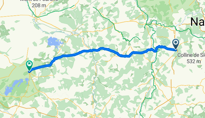
03-Colombey-les-Belles-Brienne-le-Chateau
A cycling route starting in Colombey-les-Belles, Grand Est, France.
Overview
About this route
03-Colombey-les-Belles-Brienne-le-Chateau
- -:--
- Duration
- 117.1 km
- Distance
- 594 m
- Ascent
- 793 m
- Descent
- ---
- Avg. speed
- ---
- Max. altitude
Route quality
Waytypes & surfaces along the route
Waytypes
Busy road
82.6 km
(71 %)
Road
24.4 km
(21 %)
Surfaces
Paved
55.3 km
(47 %)
Unpaved
0.4 km
(<1 %)
Asphalt
55.3 km
(47 %)
Gravel
0.4 km
(<1 %)
Undefined
61.4 km
(52 %)
Continue with Bikemap
Use, edit, or download this cycling route
You would like to ride 03-Colombey-les-Belles-Brienne-le-Chateau or customize it for your own trip? Here is what you can do with this Bikemap route:
Free features
- Save this route as favorite or in collections
- Copy & plan your own version of this route
- Split it into stages to create a multi-day tour
- Sync your route with Garmin or Wahoo
Premium features
Free trial for 3 days, or one-time payment. More about Bikemap Premium.
- Navigate this route on iOS & Android
- Export a GPX / KML file of this route
- Create your custom printout (try it for free)
- Download this route for offline navigation
Discover more Premium features.
Get Bikemap PremiumFrom our community
Other popular routes starting in Colombey-les-Belles
 1er tour test Favières Vandeléville gelaucourt
- Distance
- 18.7 km
- Ascent
- 204 m
- Descent
- 204 m
- Location
- Colombey-les-Belles, Grand Est, France
 chemin boueux Allain
- Distance
- 7.8 km
- Ascent
- 88 m
- Descent
- 93 m
- Location
- Colombey-les-Belles, Grand Est, France
 saulxerotte battigny
- Distance
- 10.4 km
- Ascent
- 126 m
- Descent
- 125 m
- Location
- Colombey-les-Belles, Grand Est, France
 De Rue de la Ruelle 10, Allain à Rue Etienne Olry 35, Allain
- Distance
- 48.8 km
- Ascent
- 497 m
- Descent
- 498 m
- Location
- Colombey-les-Belles, Grand Est, France
 BS E4
BS E4- Distance
- 166.6 km
- Ascent
- 829 m
- Descent
- 991 m
- Location
- Colombey-les-Belles, Grand Est, France
 C030-Bagneux-Neufchâteau
- Distance
- 28.6 km
- Ascent
- 251 m
- Descent
- 530 m
- Location
- Colombey-les-Belles, Grand Est, France
 Autoroute de Lorraine-Bourgogne nach Rue de la Fontaine
- Distance
- 105.9 km
- Ascent
- 1,209 m
- Descent
- 1,138 m
- Location
- Colombey-les-Belles, Grand Est, France
 Colombey-les-Belles - Marcilly-sur-Tille
- Distance
- 138.4 km
- Ascent
- 214 m
- Descent
- 174 m
- Location
- Colombey-les-Belles, Grand Est, France
Open it in the app