

Rheinhessisches Hügelland
A cycling route starting in Undenheim, Rhineland-Palatinate, Germany.
Overview
About this route
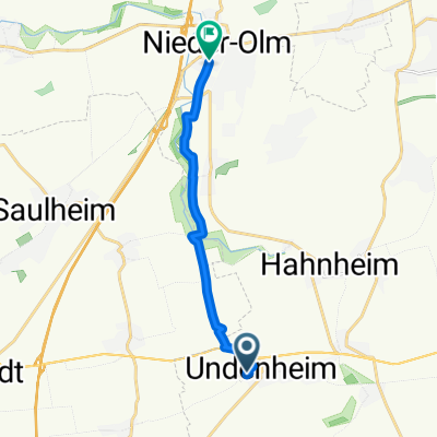
Route with two challenging climbs between Nieder-Olm and Mainz-Ebersheim as well as Schwabsburg and Dexheim
- -:--
- Duration
- 58 km
- Distance
- 411 m
- Ascent
- 408 m
- Descent
- ---
- Avg. speed
- 236 m
- Max. altitude
Route quality
Waytypes & surfaces along the route
Waytypes
Road
12.2 km
(21 %)
Track
8.1 km
(14 %)
Surfaces
Paved
49.9 km
(86 %)
Unpaved
3.5 km
(6 %)
Asphalt
48.1 km
(83 %)
Ground
2.9 km
(5 %)
Continue with Bikemap
Use, edit, or download this cycling route
You would like to ride Rheinhessisches Hügelland or customize it for your own trip? Here is what you can do with this Bikemap route:
Free features
- Save this route as favorite or in collections
- Copy & plan your own version of this route
- Sync your route with Garmin or Wahoo
Premium features
Free trial for 3 days, or one-time payment. More about Bikemap Premium.
- Navigate this route on iOS & Android
- Export a GPX / KML file of this route
- Create your custom printout (try it for free)
- Download this route for offline navigation
Discover more Premium features.
Get Bikemap PremiumFrom our community
Other popular routes starting in Undenheim
 Undenheimer RTF 2013 des RSV 1921 Undenheim e.V. - 112 km Strecke
- Distance
- 109 km
- Ascent
- 648 m
- Descent
- 647 m
- Location
- Undenheim, Rhineland-Palatinate, Germany
 Undenheimer RTF 2011 des RSV 1921 Undenheim e.V. - 151 km Strecke
- Distance
- 148.9 km
- Ascent
- 769 m
- Descent
- 769 m
- Location
- Undenheim, Rhineland-Palatinate, Germany
 Rheinhessisches Hügelland
- Distance
- 58 km
- Ascent
- 411 m
- Descent
- 408 m
- Location
- Undenheim, Rhineland-Palatinate, Germany
 20170528_080203.gpx
- Distance
- 86.8 km
- Ascent
- 521 m
- Descent
- 521 m
- Location
- Undenheim, Rhineland-Palatinate, Germany
 Kleeblattmarathon
- Distance
- 199.4 km
- Ascent
- 910 m
- Descent
- 910 m
- Location
- Undenheim, Rhineland-Palatinate, Germany
 Staatsrat-Schwamb-Straße 50, Undenheim nach Lehrer-Wagner-Straße 4, Selzen
- Distance
- 4.5 km
- Ascent
- 15 m
- Descent
- 21 m
- Location
- Undenheim, Rhineland-Palatinate, Germany
 Am Eisweiher, Undenheim nach Pariser Straße, Nieder-Olm
- Distance
- 9.4 km
- Ascent
- 42 m
- Descent
- 61 m
- Location
- Undenheim, Rhineland-Palatinate, Germany
 Rheinhessen-Kleeblatt-Marathon 2013 - Marathon des RSV 1921 Undenheim e.V. - 204 km Strecke
- Distance
- 205.1 km
- Ascent
- 862 m
- Descent
- 862 m
- Location
- Undenheim, Rhineland-Palatinate, Germany
Open it in the app