
Hochebene Champ du feu
A cycling route starting in Andlau, Grand Est, France.
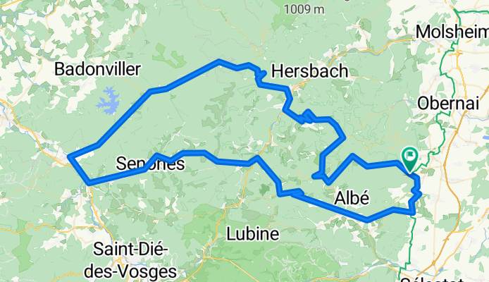
Overview
About this route
Steep climbs, magnificent viewpoints, most elevation gain in the first 50 km. Sensational long descents on very good, wide roads, just be careful in the areas around towns, as there are potholes where you can disappear!
Raon l'Étap can be passed quickly, with hundreds of trucks rolling through there.- -:--
- Duration
- 142.7 km
- Distance
- 1,783 m
- Ascent
- 1,783 m
- Descent
- ---
- Avg. speed
- ---
- Max. altitude
Route quality
Waytypes & surfaces along the route
Waytypes
Road
11.4 km
(8 %)
Quiet road
2.9 km
(2 %)
Undefined
128.5 km
(90 %)
Surfaces
Paved
58.5 km
(41 %)
Asphalt
58.5 km
(41 %)
Undefined
84.2 km
(59 %)
Continue with Bikemap
Use, edit, or download this cycling route
You would like to ride Hochebene Champ du feu or customize it for your own trip? Here is what you can do with this Bikemap route:
Free features
- Save this route as favorite or in collections
- Copy & plan your own version of this route
- Split it into stages to create a multi-day tour
- Sync your route with Garmin or Wahoo
Premium features
Free trial for 3 days, or one-time payment. More about Bikemap Premium.
- Navigate this route on iOS & Android
- Export a GPX / KML file of this route
- Create your custom printout (try it for free)
- Download this route for offline navigation
Discover more Premium features.
Get Bikemap PremiumFrom our community
Other popular routes starting in Andlau
 Le Hohwald-selestad
- Distance
- 49.9 km
- Ascent
- 713 m
- Descent
- 1,127 m
- Location
- Andlau, Grand Est, France
 Itterswiller - Obernai
- Distance
- 32.4 km
- Ascent
- 322 m
- Descent
- 322 m
- Location
- Andlau, Grand Est, France
 Hochebene Champ du feu
- Distance
- 142.7 km
- Ascent
- 1,783 m
- Descent
- 1,783 m
- Location
- Andlau, Grand Est, France
 Vogesen -Andlau
- Distance
- 49.1 km
- Ascent
- 1,663 m
- Descent
- 1,627 m
- Location
- Andlau, Grand Est, France
 Mont St. Odile
- Distance
- 61.6 km
- Ascent
- 1,238 m
- Descent
- 1,221 m
- Location
- Andlau, Grand Est, France
 De 1 Route du Hohwald, Eichhoffen à D603, Eichhoffen
- Distance
- 1.3 km
- Ascent
- 32 m
- Descent
- 0 m
- Location
- Andlau, Grand Est, France
 Mont St. Odile
- Distance
- 35.5 km
- Ascent
- 702 m
- Descent
- 702 m
- Location
- Andlau, Grand Est, France
 Weinrote 2 / Eichhoffen-Andlau (siehe Höhen)Scherwiler-Ebersheim-Kogenheim-EPFIG (!!!) - Auto
- Distance
- 44.7 km
- Ascent
- 173 m
- Descent
- 177 m
- Location
- Andlau, Grand Est, France
Open it in the app