
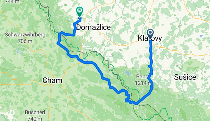
Klatovy - Otov
A cycling route starting in Klatovy, Plzeň Region, Czechia.
Overview
About this route
Klatovy - Železná Ruda - Otov
- -:--
- Duration
- 127.3 km
- Distance
- 1,765 m
- Ascent
- 1,757 m
- Descent
- ---
- Avg. speed
- ---
- Max. altitude
Route quality
Waytypes & surfaces along the route
Waytypes
Road
17.8 km
(14 %)
Quiet road
6.4 km
(5 %)
Surfaces
Paved
66.2 km
(52 %)
Unpaved
1.3 km
(1 %)
Asphalt
63.7 km
(50 %)
Paved (undefined)
2.5 km
(2 %)
Continue with Bikemap
Use, edit, or download this cycling route
You would like to ride Klatovy - Otov or customize it for your own trip? Here is what you can do with this Bikemap route:
Free features
- Save this route as favorite or in collections
- Copy & plan your own version of this route
- Split it into stages to create a multi-day tour
- Sync your route with Garmin or Wahoo
Premium features
Free trial for 3 days, or one-time payment. More about Bikemap Premium.
- Navigate this route on iOS & Android
- Export a GPX / KML file of this route
- Create your custom printout (try it for free)
- Download this route for offline navigation
Discover more Premium features.
Get Bikemap PremiumFrom our community
Other popular routes starting in Klatovy
 výlet 10.8.2014 klatovy - hrádek u sušice
- Distance
- 75.4 km
- Ascent
- 704 m
- Descent
- 701 m
- Location
- Klatovy, Plzeň Region, Czechia
 HMB-Zatec + Klatovy-HMB
- Distance
- 323.3 km
- Ascent
- 4,306 m
- Descent
- 4,463 m
- Location
- Klatovy, Plzeň Region, Czechia
 Šumavská do Úzká
- Distance
- 52.4 km
- Ascent
- 486 m
- Descent
- 598 m
- Location
- Klatovy, Plzeň Region, Czechia
 Author MTB Král Šumavy 2010 - 70km CLONED FROM ROUTE 509878
- Distance
- 66.2 km
- Ascent
- 1,186 m
- Descent
- 1,216 m
- Location
- Klatovy, Plzeň Region, Czechia
 Král Šumavy 2009 - 2011, trasa 150 km
- Distance
- 151.1 km
- Ascent
- 1,785 m
- Descent
- 1,779 m
- Location
- Klatovy, Plzeň Region, Czechia
 Kral Sumavy 08-dlouha
- Distance
- 237.2 km
- Ascent
- 4,635 m
- Descent
- 4,517 m
- Location
- Klatovy, Plzeň Region, Czechia
 Král Šumavy 2009 - 2011, dlouhá a střední trasa
- Distance
- 248.1 km
- Ascent
- 4,645 m
- Descent
- 4,541 m
- Location
- Klatovy, Plzeň Region, Czechia
 lehounká "časovka" okolo Klatov
- Distance
- 27.4 km
- Ascent
- 207 m
- Descent
- 207 m
- Location
- Klatovy, Plzeň Region, Czechia
Open it in the app