

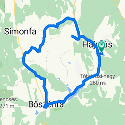
Igal-Deseda-2
A cycling route starting in Taszár, Somogy County, Hungary.
Overview
About this route
Kellemes kis túra, enyhe dombokkal tarkítva!
- -:--
- Duration
- 54.6 km
- Distance
- 314 m
- Ascent
- 314 m
- Descent
- ---
- Avg. speed
- ---
- Max. altitude

Route quality
Waytypes & surfaces along the route
Waytypes
Track
10.4 km
(19 %)
Cycleway
8.2 km
(15 %)
Surfaces
Paved
36 km
(66 %)
Unpaved
10.9 km
(20 %)
Asphalt
35.5 km
(65 %)
Ground
7.6 km
(14 %)
Continue with Bikemap
Use, edit, or download this cycling route
You would like to ride Igal-Deseda-2 or customize it for your own trip? Here is what you can do with this Bikemap route:
Free features
- Save this route as favorite or in collections
- Copy & plan your own version of this route
- Sync your route with Garmin or Wahoo
Premium features
Free trial for 3 days, or one-time payment. More about Bikemap Premium.
- Navigate this route on iOS & Android
- Export a GPX / KML file of this route
- Create your custom printout (try it for free)
- Download this route for offline navigation
Discover more Premium features.
Get Bikemap PremiumFrom our community
Other popular routes starting in Taszár
 Igal-Kapospula-Igal
- Distance
- 57.1 km
- Ascent
- 239 m
- Descent
- 239 m
- Location
- Taszár, Somogy County, Hungary
 2016.06.10-11-12. Somogyország az Én Hazám
- Distance
- 164.5 km
- Ascent
- 638 m
- Descent
- 638 m
- Location
- Taszár, Somogy County, Hungary
 Várong, kaktuszfarm
- Distance
- 11.1 km
- Ascent
- 112 m
- Descent
- 120 m
- Location
- Taszár, Somogy County, Hungary
 Hajmás - Hajmás
- Distance
- 26.4 km
- Ascent
- 268 m
- Descent
- 272 m
- Location
- Taszár, Somogy County, Hungary
 Igal-Deseda-2
- Distance
- 54.6 km
- Ascent
- 314 m
- Descent
- 314 m
- Location
- Taszár, Somogy County, Hungary
 Mecsek-Őrség-Osztrák-Szlovén
- Distance
- 620.7 km
- Ascent
- 995 m
- Descent
- 996 m
- Location
- Taszár, Somogy County, Hungary
 DDK Mecseki Kék 1
- Distance
- 16.9 km
- Ascent
- 270 m
- Descent
- 270 m
- Location
- Taszár, Somogy County, Hungary
 Tavaszi bemelegítés Igal-Mernye-Igal
- Distance
- 12.5 km
- Ascent
- 142 m
- Descent
- 163 m
- Location
- Taszár, Somogy County, Hungary
Open it in the app