

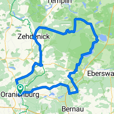
Oranienburg->Usedom
A cycling route starting in Oranienburg, Brandenburg, Germany.
Overview
About this route
Das ist die von mir schon mal gefahrene und für gut befundene Strecke um von Oranienburg nach Usedom zu gelangen.
- -:--
- Duration
- 198.8 km
- Distance
- 566 m
- Ascent
- 593 m
- Descent
- ---
- Avg. speed
- 133 m
- Max. altitude

Route quality
Waytypes & surfaces along the route
Waytypes
Busy road
88.4 km
(44 %)
Path
42.8 km
(22 %)
Surfaces
Paved
150.2 km
(76 %)
Unpaved
6.2 km
(3 %)
Asphalt
125.2 km
(63 %)
Paving stones
12.7 km
(6 %)
Route highlights
Points of interest along the route
Point of interest after 53.7 km
Hier könnte der 1. Treffpunkt sein
Point of interest after 95.7 km
Hier könnte der 2. Treffpunkt sein
Point of interest after 140.7 km
Hier könnte der 3. Treffpunkt sein
Point of interest after 162.8 km
Hier könnte der 4. Treffpunkt sein
Continue with Bikemap
Use, edit, or download this cycling route
You would like to ride Oranienburg->Usedom or customize it for your own trip? Here is what you can do with this Bikemap route:
Free features
- Save this route as favorite or in collections
- Copy & plan your own version of this route
- Split it into stages to create a multi-day tour
- Sync your route with Garmin or Wahoo
Premium features
Free trial for 3 days, or one-time payment. More about Bikemap Premium.
- Navigate this route on iOS & Android
- Export a GPX / KML file of this route
- Create your custom printout (try it for free)
- Download this route for offline navigation
Discover more Premium features.
Get Bikemap PremiumFrom our community
Other popular routes starting in Oranienburg
 510. Groß Väter
- Distance
- 146.3 km
- Ascent
- 183 m
- Descent
- 185 m
- Location
- Oranienburg, Brandenburg, Germany
 Girolibero: Berlino Rostock Copenhagen
- Distance
- 531.2 km
- Ascent
- 367 m
- Descent
- 390 m
- Location
- Oranienburg, Brandenburg, Germany
 Zeitfahrstrecke
- Distance
- 18 km
- Ascent
- 49 m
- Descent
- 42 m
- Location
- Oranienburg, Brandenburg, Germany
 15/3 Oranienburg - Oderberg
- Distance
- 76.5 km
- Ascent
- 89 m
- Descent
- 124 m
- Location
- Oranienburg, Brandenburg, Germany
 Kölle
Kölle- Distance
- 20 km
- Ascent
- 58 m
- Descent
- 58 m
- Location
- Oranienburg, Brandenburg, Germany
 Oranienburg-Greifswald
- Distance
- 167.7 km
- Ascent
- 260 m
- Descent
- 294 m
- Location
- Oranienburg, Brandenburg, Germany
 perm Zabelsdorf
- Distance
- 71.4 km
- Ascent
- 139 m
- Descent
- 141 m
- Location
- Oranienburg, Brandenburg, Germany
 perm Lindow
- Distance
- 80.5 km
- Ascent
- 241 m
- Descent
- 239 m
- Location
- Oranienburg, Brandenburg, Germany
Open it in the app