

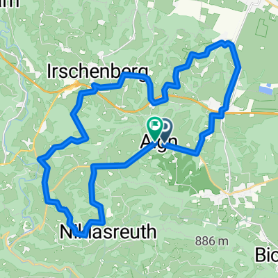
Irschenberg - 2013 - 1
A cycling route starting in Irschenberg, Bavaria, Germany.
Overview
About this route
Irschenberg 2 x jeweils OST - WEST + 1 x Seehamer See
(cloned from route 2169284)- -:--
- Duration
- 14.2 km
- Distance
- 359 m
- Ascent
- 359 m
- Descent
- ---
- Avg. speed
- ---
- Max. altitude
Route quality
Waytypes & surfaces along the route
Waytypes
Quiet road
8.2 km
(58 %)
Road
5.8 km
(41 %)
Surfaces
Paved
13.6 km
(96 %)
Asphalt
13.6 km
(96 %)
Undefined
0.6 km
(4 %)
Continue with Bikemap
Use, edit, or download this cycling route
You would like to ride Irschenberg - 2013 - 1 or customize it for your own trip? Here is what you can do with this Bikemap route:
Free features
- Save this route as favorite or in collections
- Copy & plan your own version of this route
- Sync your route with Garmin or Wahoo
Premium features
Free trial for 3 days, or one-time payment. More about Bikemap Premium.
- Navigate this route on iOS & Android
- Export a GPX / KML file of this route
- Create your custom printout (try it for free)
- Download this route for offline navigation
Discover more Premium features.
Get Bikemap PremiumFrom our community
Other popular routes starting in Irschenberg
 Irschenberg - 2013 - 1
- Distance
- 22.6 km
- Ascent
- 359 m
- Descent
- 359 m
- Location
- Irschenberg, Bavaria, Germany
 Traumtour Valepp_Sudelfeld
- Distance
- 103.2 km
- Ascent
- 1,959 m
- Descent
- 2,125 m
- Location
- Irschenberg, Bavaria, Germany
 Irschenberg Radfahren
- Distance
- 59.1 km
- Ascent
- 519 m
- Descent
- 522 m
- Location
- Irschenberg, Bavaria, Germany
 Irschenberg - Wasserburg am Inn - Chiemsee - Irschenberg
- Distance
- 140.3 km
- Ascent
- 776 m
- Descent
- 780 m
- Location
- Irschenberg, Bavaria, Germany
 Gravelation 2.3
- Distance
- 97.7 km
- Ascent
- 923 m
- Descent
- 922 m
- Location
- Irschenberg, Bavaria, Germany
 Tregler Alm 28km Runde
- Distance
- 27.8 km
- Ascent
- 771 m
- Descent
- 771 m
- Location
- Irschenberg, Bavaria, Germany
 Niklasreuth Rundkurs 26km 580hm
- Distance
- 19.2 km
- Ascent
- 542 m
- Descent
- 490 m
- Location
- Irschenberg, Bavaria, Germany
 Route in Bad Feilnbach
- Distance
- 27 km
- Ascent
- 477 m
- Descent
- 475 m
- Location
- Irschenberg, Bavaria, Germany
Open it in the app