

2009-06-17 agostyán
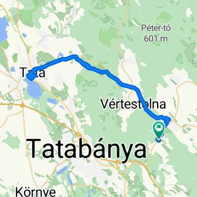
A cycling route starting in Tarján, Komárom-Esztergom, Hungary.
Overview
About this route
0
moving time: 3h 2m
stopped time: 10 m
max. speed 72,6 km/h
average speed: 18,8 km/h
total ascent: 735 m
- -:--
- Duration
- 60.4 km
- Distance
- 629 m
- Ascent
- 601 m
- Descent
- ---
- Avg. speed
- 320 m
- Max. altitude
garp
created this 17 years ago
Route quality
Waytypes & surfaces along the route
Waytypes
Quiet road
11.5 km
19 %
Road
6 km
10 %
Surfaces
Paved
32 km
(53 %)
Unpaved
4.2 km
(7 %)
Asphalt
30.8 km
51 %
Ground
3.6 km
6 %
Continue with Bikemap
Use, edit, or download this cycling route
You would like to ride 2009-06-17 agostyán or customize it for your own trip? Here is what you can do with this Bikemap route:
Free features
- Save this route as favorite or in collections
- Copy & plan your own version of this route
- Sync your route with Garmin or Wahoo
Premium features
Free trial for 3 days, or one-time payment. More about Bikemap Premium.
- Navigate this route on iOS & Android
- Export a GPX / KML file of this route
- Create your custom printout (try it for free)
- Download this route for offline navigation
Discover more Premium features.
Get Bikemap PremiumFrom our community
Other popular routes starting in Tarján
- Szőlőhegy utca 2, Tarján - Móricz Zsigmond tér 11, Tarján0
- 3.7 km
- 75 m
- 100 m
- Tarján, Komárom-Esztergom, Hungary
- Camino De Santiago-Szt Jakab Zarándokút, Csabdi - Bicskei utca, Tarján0
- 6.4 km
- 84 m
- 63 m
- Tarján, Komárom-Esztergom, Hungary


Open it in the app